

Lidar
In 2015, the Washington State Legislature mandated that the Department of Natural Resources, Washington Geological Survey, collect, analyze, and publicly distribute detailed information about our state's geology using the best available technology - lidar. The main focus of this new push for lidar collection is to map landslides, but there are innumerable additional benefits and applications of this data both inside and outside of the field of geology.
The Survey has set up a new lidar program and has begun collecting, inventorying, processing, and storing existing lidar data. New airborne lidar collection is underway, starting with areas at higher risk for landslides that do not already have high-quality lidar data.
The goal of the project is to gather high-quality lidar data for the whole state. Roughly 25 to 35% of the state has been flown, but the landscape changes over time, as does technology. Just as importantly, much of the state only has poor-quality lidar coverage that is of limited use to those relying on the information. These lidar collection flights were either scheduled during seasons where leaves are still on deciduous trees or with lower point-density specifications. Many areas that have already been collected will be scanned again at better resolution in order to be of use in landslide hazard assessments.
- What is Lidar?
-
Lidar stands for LIght Detection And Ranging and the physics behind it are pretty simple. By pointing a laser at a surface at closely spaced intervals and measuring the time it takes for light to return to the source, very accurate three-dimensional information can be obtained with sufficient measurements. Billions of these measurements can yield an extremely detailed three-dimensional rendering of the terrain.
The instrument that collects the data is made up of a laser, scanner, and GPS receiver. For ground scanning operations, the laser is typically a near-infrared laser. For water-based surveys, a green wavelength laser is typically used. Green lasers are visible to the human eye and will penetrate shallow water, making them ideal for coastal surveys. Near-infrared lasers are invisible and harmless to the eye, but cannot penetrate below the surface of water. Unlike green lasers, water absorbs the energy from the near-infrared laser rather than reflecting it.

The instrument is mounted to a light aircraft, car, or static survey platform where an eye-safe laser measures objects with an accuracy of about 1 inch. Scanning over 100,000 points a second, the laser reflects off trees, buildings, streets, shrubs, people, and the ground. Flight paths are planned so that there is over 100% overlap of individual flight segments, such that (a) every square meter of ground is covered twice, and (b) the number of points per square meter meets project specifications. A computer sorts the points and separates them for different uses, though it requires a specialist to process and interpret the lidar data.
The light is measured and calibrated using GPS, survey stations, and computer processing. Points representing the measurement locations are then created with a latitude, longitude, and height value. Millions to billions of points make up one dataset and are called point clouds. These points are sorted (classified) into different groupings according to what the laser hit. The main groups are first and last returns. First returns are the beams that reach the device first. This means they generally reflect the tops of vegetation, unless the ground is bare. The last return can be the ground surface, or it can return from low-lying vegetation. Dense forests, especially when leaves are on the trees, are difficult for the laser to fully penetrate. Using complex computer algorithms, the returns are usually categorized into tree top, bare earth, buildings, vegetation, and water.
Lidar point clouds are used to create derivative products. Commonly, models show the surface of the earth without vegetation. Other elevation models depict information such as forest canopy, slope angle, slope direction, stream flow, elevation contours, 3D models of buildings, people, and more.

- How is Lidar Used?
-
Lidar is widely used for many different applications. Some (but by no means all) of those uses are described below.
Geology and Hazards
In geology, bare earth models allow closer study of geomorphology, which is the study of the origin of the topography of the earth. Floods, faults, landslides, erosion, and glaciers leave their mark on the landscape, and while these marks can be hidden by dense vegetation, they can't hide from lidar.
Many, but not all, of the applications specific to geology are described below. Lidar is also used in natural resources conservation, water supply and quality assessments, river and stream resource management, and mining resource management.
Landslides
Before the use of lidar became widespread, geologists used aerial photographs, topographic maps, and field surveys to catalog landslides. This method is problematic in Washington because of the density of vegetation that often either obscures features or makes field-checking difficult.
Landslides often have characteristic topography that is obvious once that topography is visible. Slump blocks, hummocky topography, scarps, and sag ponds can all identify a landslide. With lidar, a geologist can go over large tracts of land to find landslides quickly and more accurately than using aerial photographs alone.

Aerial imagery of a large landslide south of Kendall on the east side of Sumas Mountain. 
Lidar imagery reveals the bare earth at a large landslide south of Kendall on the east side of Sumas Mountain. Faults
Signs of young faults include sag pongs, offset stream beds, and linear scarps. Lidar gives geologists the ability to find these features no matter what the ground cover is like or if the feature is partly eroded.

This picture shows imagery of fault scarps in lidar (red arrows point to faults). These faults are located just east of Lake Cushman, on the southeast Olympic Peninsula, and have created a sag pond, Price Lake. 
Locations of faults mapped over the lidar base map. Compare this image with the image at left to see the fault scarp traces. Geologic Mapping
Lidar allows geologists to find subtle geologic features that might otherwise be missed. Features such as landslides, faults, river terraces, drumlins, glacial outwash channels, alluvial fans, eskers, and fluting are readily apparent when high-quality lidar imagery is available. Landform analysis can be used to extrapolate field findings to correlate geologic units across different areas.

A geologic map without lidar. Compare this with the image to the right. 
A geologic map with a lidar underlay. Lidar enhances the readability of the terrain. The steepness of the river channel and the identity of other geologic features instantly become obvious. Flood Risk Management
Lidar is useful for many hydrologic applications. Floodplains can be mapped in detail. Models can be created to show where areas are at risk of flooding. Subtle river features, such as abandoned channels, ditches, terraces, and levees can be identified. This allows land managers and decision-makers to manage flood zones, preserve the natural functions of floodplains, and better craft emergency response procedures.

Elevation model from Information Circular 118, showing features of the Chehalis River floodplain derived from lidar elevation data. Tsunamis
Tsunamis are a potential threat in coastal regions. Lidar gives scientists an accurate surface representation of the ground, allowing models to more accurately forecast where a tsunami could inundate an area. This modeling can give residents the ability to plan where to evacuate during an emergency.
Water and Ice
Lidar is used to monitor the growth or decline of glaciers. Repeated monitoring over the same area documents the effects of climate change or geologic activity. Additionally, geologists can use lidar to discern the glacial history from the last ice age.

Kettles are depressions resulting from glacial ice left behind as the glacier retreated. The blocks of ice were buried by sand and gravel from glacial streams and subsequently melted in place. These kettles are part of the Budd Inlet Kettle Train, just south of Olympia. Lidar can be used to monitor coastal regions. Repeated runs of lidar can be used to monitor the effects of currents and storms that migrate large amounts of sediment very quickly.
Volcanology
Repeated measurement over time can be used to monitor volcanic activity. Mount St. Helens is an example of this, as lidar was used to document dome building at the summit between 2002 and 2004.
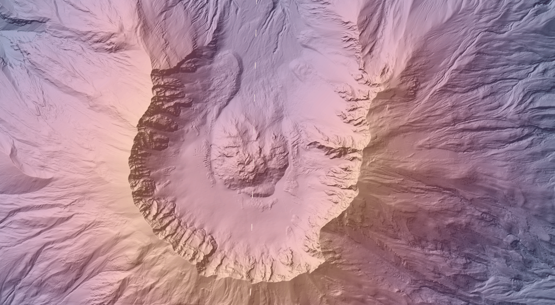
Lidar can also be used to map lahar hazards. Accurate models of topography downstream from volcanoes can be used to predict lahar travel paths, pinpoint danger zones, and identify safe evacuation routes.
Forestry
Using bare earth and tree canopy models created from lidar, it's possible to look at large areas of forests in great detail. These and other models can be used to estimate volume, density, mass, leaf area, canopy heights, and growth rate. These data are used to plan logging, estimate yield, map biodiversity, locate wildlife habitat, and plan conservation efforts.

Individual tree crowns, tree height, and density can be analyzed with lidar. 
Analysis of lidar elevation data can produce detailed models of stream flow in watersheds. Graphics
Lidar can also be used to render physical objects graphically. Cities, individual buildings, cars, and other objects can be modeled in a 3D environment. These models can then be used to make video games, recreate the scene of an accident or crime, help plan building restoration, and more.
Lidar can be used to map out all of the details of a building inside and out. This is useful if, for example, someone wants to recreate an entire stadium for use in a video game. A stationary lidar survey platform can model the whole building much faster and more accurately than an artist.
Navigation

Autonomous car outfitted with lidar and cameras. Photo by Steve Jurvetson, (Creative Commons license) Lidar is now being used in autonomous navigation. The systems use lasers to measure distance and speed for all surrounding objects, allowing the car's computer to map its surroundings in real time. This allows for adaptive speed relative to traffic in front of the vehicle, adaptive suspension, and automatic parking.
Similarly, aerial robots can use lidar to map the terrain below them. This allows them to safely avoid obstacles and land by measuring the robot's speed and position relative to its surroundings. The software can use the lidar data to classify objects it finds, allowing military robots to identify targets.
Meteorology and Fire
Lidar is used to detect atmospheric conditions, such as composition, structure, wind speed and shear, and aerosols. Pollution and gases (for example, ozone, carbon dioxide, or water vapor) in the atmosphere can be measured this way. Lidar robots can be deployed to measure air quality in confined, potentially hazardous locations.
Lidar is also being used experimentally to map smoke from wildfires and to estimate fuel availability and density for wildfire modeling.

The Chiwaukum Fire, started by lightning, burned more than 14,000 acres in July 2014. Archaeology
Lidar can be used in the field of archaeology to find things hidden by the forest canopy. Large features that would be indistinguishable on the ground are readily apparent in a lidar survey, leading archaeologists to sites they might not have otherwise found. For example, intensity returns can be used to detect features just below the surface that affect plant growth.
Lidar rendering of Stonehenge and surrounding barrows. Land-Use Planning
Lidar can be used to identify and map streets, highways, railroads, grades, levees, buildings, and other man-made features. Combined with hazard mapping, it allows planners to find the best location to build. Planners can also use the information to calculate line of sight, and identify building height. Areas where cut and fill are needed can be measured with accuracy for road planning.

Combined top surface elevation, hillshade, and slope map of the Tacoma Dome, Tacoma, WA. Traditional surveying is very time consuming and labor intensive due to the high amount of accuracy required. With lidar, engineers can use these models to perform analyses of areas without ever setting foot there. For example, they can accurately identify trees growing too close to utilities that need to be cleared. Or a hydroelectric dam can be examined to identify subsidence, perform hydrologic modeling, or look at water levels to ensure continued safety.
Agriculture
Lidar can also be used in agriculture to determine slope angle and direction. These factors help to calculate possible crop yield, precisely locate and determine amounts of fertilizer placement to maximize crop yield, and to plan efficient drainage. Lidar can also be used to maintain orchard health: to see where trees need pruning, count trees, or other maintenance needs.

Bare earth hillshade and elevation of cropland near Ellensburg, showing southwest drainage, irrigation pipelines, and drainage canals. 
Orchard land near Entiat showing the tree canopy hillshade and elevation.
- The Washington State Lidar Plan
-
The Washington State Lidar Plan provides an overview of lidar in Washington State for potential users of lidar data, such as cities, counties, state agencies, federal agencies, and tribes. The report includes an overview of past data collection efforts, a list of stakeholders, a summary of the value of lidar data, and a strategy for completing statewide lidar coverage. The plan includes priority areas and estimated funding. This is the State's first formal statewide lidar plan, and it will be updated annually. Click the link below to download the plan and don't forget to take a look at our accompanying Story Map!
Click here to download the Washington State Lidar Plan.
The plan represents a collaboration between the Department of Natural Resources (DNR) and the Office of the Chief Information Officer (OCIO). Contact Abby Gleason (DNR) or Joanne Markert (OCIO) for more details about the State Lidar Plan.
- The Lidar Portal
-

The Washington Department of Natural Resources Lidar portal currently offers the ability to download Digital Elevation Models (DEMs), hillshade derivatives, and point cloud data for about a third of DNR's data holdings. We will continuously add to the site as we receive new datasets and make improvements, so check back often for updates!
Lidar data can also be freely downloaded on the Puget Sound Lidar Consortium website. Other sites with Washington State lidar data include the Open Topography Interactive Map, the USGS National Map Viewer, and the NOAA Data Access Viewer.
- Current Projects
-
The map below shows currently ongoing or planned lidar projects in Washington State.
If you are planning a lidar project or know about an ongoing project, we'd like to learn more! Please contact us.

- How to Become a Partner
-
We have developed a lidar program with the goal of increasing understanding of geologic hazards, collection of consistent, high-quality lidar data, the creation of a lidar portal for public use, and outreach and education with the public and other interested parties.
Click the image below to view more information about working with our lidar program.

If your organization would like to partner with the Department of Natural Resources to fly lidar in areas not currently planned, please contact the Lidar Manager Abby Gleason for more details.