You’ve come to the right place! It’s still DNR’s website, just more mobile-friendly and accessible.

Landslides
The Landslide Hazards Program at the Washington Geological Survey maps, studies, and monitors landslides, alluvial fans, and rockfall in Washington for the benefit of the public. The team synthesizes lidar-based mapping, field observations, and physical science to improve landslide risk assessments and to communicate the latest landslide information.
Landslides are movements of soil, rock, and debris downslope. Landslides occur regularly around the world, causing thousands of deaths and billions of dollars in damages annually.
Washington is one of the most landslide-prone states in the U.S., with landslides in Washington causing tens to hundreds of millions of dollars in annual damages. Landslides are common in Washington due to unstable glacial sediment in many areas, frequent earthquakes that can trigger landslides, and steep terrain, including both mountain slopes and coastal bluffs. In Washington, landslides are most common in the winter wet season, but significant landslides can occur at any time of year. While there is no way to eliminate landslides, mapping, studying, and monitoring landslide-prone areas is an effective way to minimize the impacts of landslides.
- What We Do
-
The Landslide Hazards Program works to identify and understand landslide hazards in Washington. Understanding these hazards and where they are located is critical to minimizing risk. Our team maps, monitors, and responds to landslides across the state, serving community partners with landslide information to support decision-making.
Landslides occur in urban, suburban, and rural areas across Washington. As development expands into landslide-prone areas, it is increasingly critical to map and understand landslides. Further, climate change is increasing landslide hazard with higher probabilities of both heavy rains and large wildfires—both of which enhance landslide risk. While it is impossible to eliminate landslides, our work aims to minimize the risk to people and structures.
Landslide Inventory Mapping
A core component of our work is mapping the locations of past landslides. These maps inform where to expect future events, as landslides frequently re-occur in the same places.
We use a standard landslide mapping protocol to map landslides, alluvial fans, and rockfall to maintain consistency and a high standard of quality across our inventory.

Diagram that shows different types of deposits included in our landslide inventories. A and B show a landslide deposit, C shows an alluvial fan, and D shows a rockfall deposit. Our team uses lidar, satellite and aerial imagery, and field observations to digitally map landslides, using these data to assign attributes including movement type, direction, and a confidence rating. Some mapped landslides are field-checked. All are reviewed by a licensed engineering geologist. The resulting landslide inventories are publicly available and provided to decision-makers. Visit the Washington Geologic Information Portal and select the Landslides layer in the Table of Contents on the left to view the locations of mapped landslides in Washington on an interactive map.
Emergency Response
As geologists in the Landslide Hazard Program we respond to landslide hazards when State, Federal, Tribal, or local jurisdictions ask for our help. When responding to a landslide we document information about the landslide, infrastructure at risk, environmental damage, and public safety concerns based on our expertise as landslide geologists. This information improves situational awareness for emergency responders during initial response efforts, helping them make informed decisions, limit damage, and keep people safe.

The WGS may activate our Washington Geologic Hazards Clearinghouse following a landslide event where people or infrastructure are hurt, damaged, or threatened. The aim of the Clearinghouse is to provide emergency responders and interested parties with prompt information on the impacts of a significant geologic hazard event, and to collect perishable geologic information about the event that can improve understanding of future hazards.
Outreach
We collaborate with a wide range of partners to enhance knowledge of landslide hazards. By working alongside schools, universities, geoscience professionals, organizations, and communities, we aim to build a more disaster-resilient society. In addition, we provide a comprehensive collection of resources on landslides, including our Homeowner’s Guide, fact sheets, and much more.

Post-Fire Debris Flow Work
Debris flows after wildfires are a significant problem in Washington. We assess hazards and wildfires to understand and mitigate this risk. Higher intensity fires can cause soils to become water repellent after the fire. This can cause rainwater to run off slopes and into streams faster than normal. As a result, flash foods and (or) debris flows become possible with even modest rainstorms. Debris flow hazard can remain elevated in burned areas for years after a fire. As soon as we can, we publish a rapid response debris flow hazard assessment for the burned areas that have communities or infrastructure downslope.

Learn more about our Post-Wildfire Debris Flow Program.
- Signs and Triggers of Landslide Activity
-
Common landslide triggers
Natural processes and human activities can destabilize slopes, causing landslides. Heavy rainstorms trigger the most landslides in Washington. The graphics below show four common landslide triggers. Note that these processes can interact with each other, such as an earthquake after an intense rainfall event.


Landslide warning signs
Features on the landscape, unusual sounds, and other signs can indicate an imminent landslide.
The following signs indicate a landslide is moving or may be about to occur:
- Cracks growing in the ground
- Movement of rock, soil, or vegetation
- Sounds of cracking wood, knocking boulders, groaning of the ground, or other unusual sounds, especially if the sound increases
- Changes in surface or sub-surface runoff patterns
- Sudden changes in water levels in rivers and streams, sometimes with increased sediment, especially during or after large storms. This indicates a debris flow may be about to descend the river or stream channel.
- Earthquakes
This diagram shows signs of landslide activity. If you suspect an imminent landslide, evacuate and report the problem immediately to your city, county, or tribal Emergency Manager.

- Reduce Your Risk
-
Get landslide-ready!
- Stay informed! The National Weather Service Seattle office and Spokane offices monitor and predict weather across Washington and share information about flooding and landslides.
- Make a landslide emergency plan! This includes building an emergency kit, making an evacuation plan for your family, including pets, in case of a landslide, and signing up for your community's warning system.
- This ready.gov page and our Emergency Preparedness page provide more information on making a landslide emergency plan.
- Consider evacuating landslide-prone locations prior to storms which can cause flooding and (or) landslides.
- Consider landslide risk when selecting housing. Areas near steep terrain and with past landslides are likely to experience landslides in the future.
- Consult a licensed professional for a site-specific landslide evaluation.
- Divert runoff away from steep slopes into natural drainages or storm drains. Excess water on steep slopes increases landslide risk.
Situational awareness can keep you safe from landslides. Intense or prolonged rainfall, rapid snowmelt, wave or stream erosion, and earthquakes can all trigger landslides, so awareness about weather, geologic, and seismic conditions is a good way to reduce landslide risk.
Landslides can occur repeatedly in the same places—consult our interactive map of landslides in Washington to learn where landslides have occurred in the past and thus where they may occur in the future.
- Types of Landslide Movement
-
Landslides are categorized as shallow or deep-seated depending on what depth below the surface the ground fails, also known as the depth of the failure plane. Failure planes greater than 10 feet in depth are considered deep-seated landslides, while failure planes less than 10 feet in depth are considered shallow landslides. Shallow landslides typically occur during heavy rain but are possible at any time. Deep-seated landslides can occur at any time. Many landslides in Washington are a mixture of multiple slide types. Note that any landslide type can pose a serious hazard to life or property.
The diagram below labels key features that are common to many landslide types. The terminology in this figure is used in the descriptions of landslide types that follow.

Shallow landslides
Shallow landslides typically occur during the winter months in western Washington and during the summer months in eastern Washington, but are possible at any time. Shallow landslides involve failure of a thin layer of slope material typically within the vegetation rooting zone. These types of landslides are often called 'mudslides' by the news media.

Deep-seated landslides
Deep-seated landslides are those that fail below the rooting depth of trees and vegetation. They may move at different rates, varying from slow to very fast. Deep-seated landslides can cover large areas and devastate infrastructure and housing. Deep-seated landslides are typically much larger than shallow landslides, in terms of both area and volume. A deep-seated landslide may appear stable for years, decades, or even centuries. These long-lived features can be partially or entirely reactivated for a variety of reasons.

Types of Slides
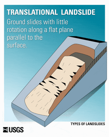
Translational landslides
Translational landslides usually fail along geologic surfaces such as faults, joints, bedding surfaces, or contacts between different rock types. They slide along a planar surface and can travel great distances. Translational slides can contain loose sediments or large slabs of bedrock.
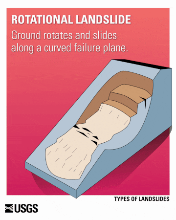
Rotational landslides (slumps)
Rotational landslides, also called slumps, are landslides that occur along a curved or spoon-shaped surface. Back-tilting of the ground may occur near the main scarp of the landslide and there is often a toe of displaced material at the bottom.
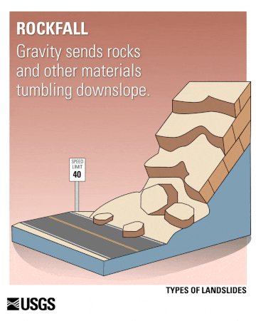
Falls and topples
Falls and topples are usually rapid, downward movement of large pieces of rock or debris. Sometimes the amount of material is enough rock to cover a road or block a stream or river. Rockfalls and topples are common in Washington’s mountain highways.

Flows
Earthflows
Earthflows involve the downhill movement of water-saturated, fine-grained soil or debris. Earthflows often have a distinctive hourglass shape. Movement speed can vary, ranging from slow, almost imperceptible creep to sudden, rapid flow and is dependent on ground conditions.

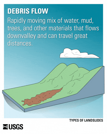
Debris Flows
Debris flows are downslope movements of water and debris, including water, mud, trees, and rocks. They usually occur in steep gullies or stream channels, may move very rapidly, and can travel for many miles. Slopes where vegetation has been removed by fire or humans may be at greater risk for debris flows and many other types of landslides. Read more about our post-fire debris flow work on our Wildfire-Associated Debris Flows page and visit our Post-Wildfire Debris Flow Dashboard to see real-time monitoring data, burn scar perimeters, and reported debris flow events.
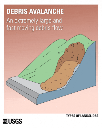
Debris Avalanches
Debris avalanches are unchannelized debris flows that are extremely large and move very rapidly.
Lahars
Lahars are debris flows that originate on volcanoes. A volcanic eruption can rapidly melt snow and ice, causing a deluge of rock, soil, ash, and water that accelerates down the slopes of a volcano, devastating anything in its path. Lahars can travel great distances and damage structures in flat areas far from their source. Communities near rivers draining Washington's volcanoes are at greatest risk.
Lateral spreads
Lateral spreads occur on very low-angle surfaces that slope toward a cliff or embankment. Movement is accompanied by cracking of the ground. Failure is often caused by liquefaction (when soil is transformed from a solid to a liquid), usually because of an earthquake.

- Interactive Landslide Maps
-
Landslide Maps
Visit the Washington Geologic Information Portal to view the locations of mapped landslides on an interactive, searchable map of Washington. Below, we illustrate and describe multiple maps WGS maintains for landslides.
Landslide Inventory
This portal view shows WGS-mapped landslides in the Seattle-Bellevue area and vicinity. Navigate the map to view mapped landslides in other parts of Washington.
Landslide Mapping Status
We are mapping landslides across Washington on an ongoing basis in areas that are identified based on their landslide hazard, population density, and other factors. The following map shows the completion status of WGS landslide mapping. Other compiled landslide mapping is available outside of these areas, but is a compilation of historic landslide mapping efforts that vary in scale, scope, and accuracy.
Use the interactive map below to see where landslide mapping has been completed, is ongoing, or is planned.
Click here to open the map in full screen.
Post-Fire Debris Flow Dashboard
We monitor burn scars and adjacent areas for debris flows for several years after wildfires. Read more about our post-fire debris flow work on our Wildfire-Associated Debris Flows page and Post-Wildfire Debris Flow Dashboard to see real-time monitoring data, burn scar perimeters, and reported debris flow events.
Recently Reported Landslides
The interactive map shows recently reported landslides based on reports from media sources, personal communications, and government agencies. The compilation is updated regularly and goes back to 2015.

Click here to navigate to this map.
Please help contribute to this statewide database; send information on recent landslides to: kate.mickelson@dnr.wa.gov
Landslide Susceptibility
Landslide susceptibility maps identify which areas are most at risk of future landslides, considering a variety of geologic data. These maps are another tool to be used alongside landslide inventories.
While landslides often re-occur in the same locations, landslides may also occur in areas that have never been unstable before. These areas that haven't had landslides before can have similar characteristics to places where landslides have occurred, and thus may experience landslides in the future.
We have published landslide susceptibility maps for Pierce County and for areas along the north side of the Columbia Gorge, and plan to publish more in the future. These susceptibility maps are available on the Geologic Information Portal by clicking “Deep Susceptibility” and “Shallow Susceptibility” under the WGS-Protocol Landslide Mapping layer.
- Historic Landslides
-
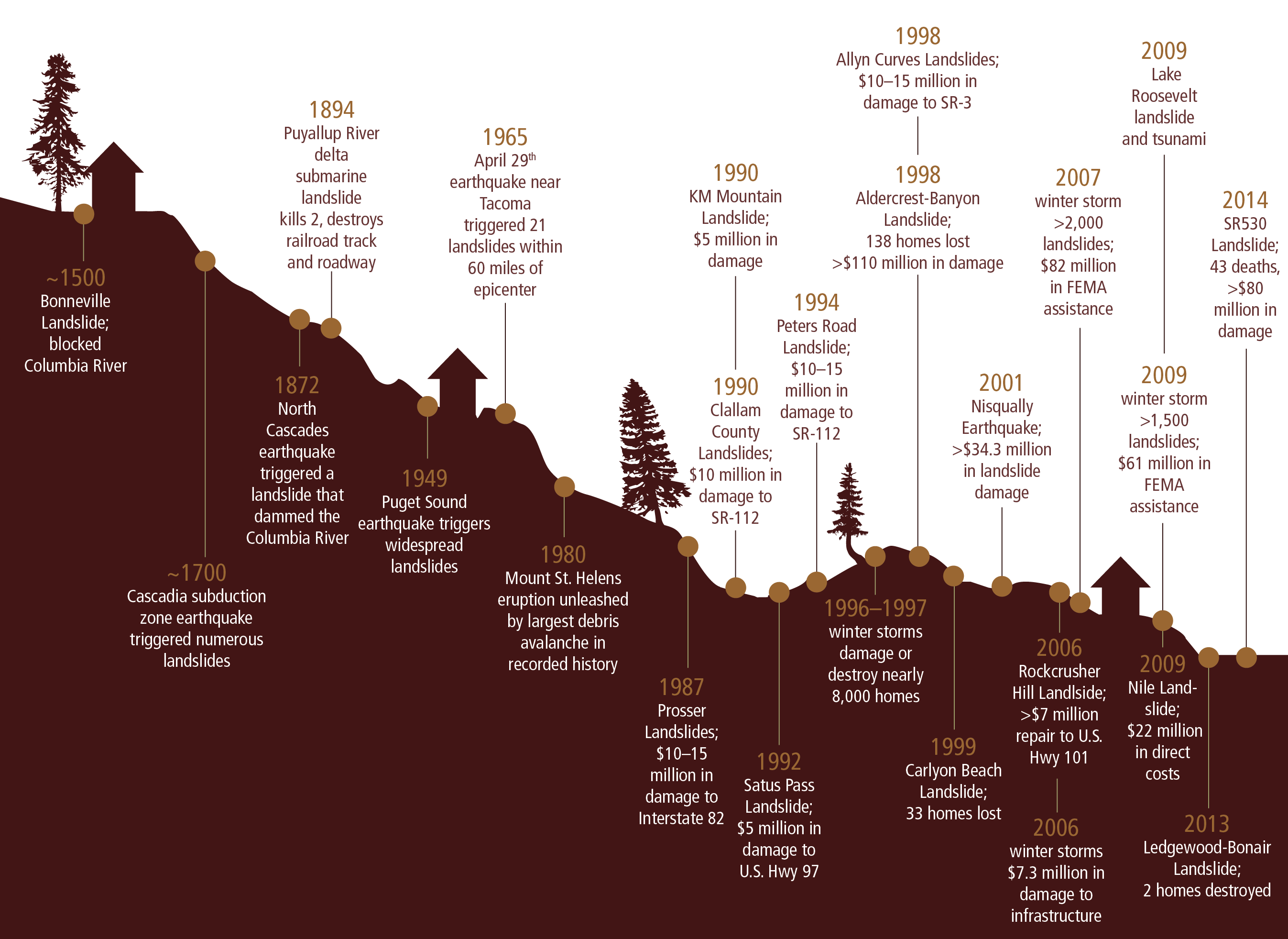
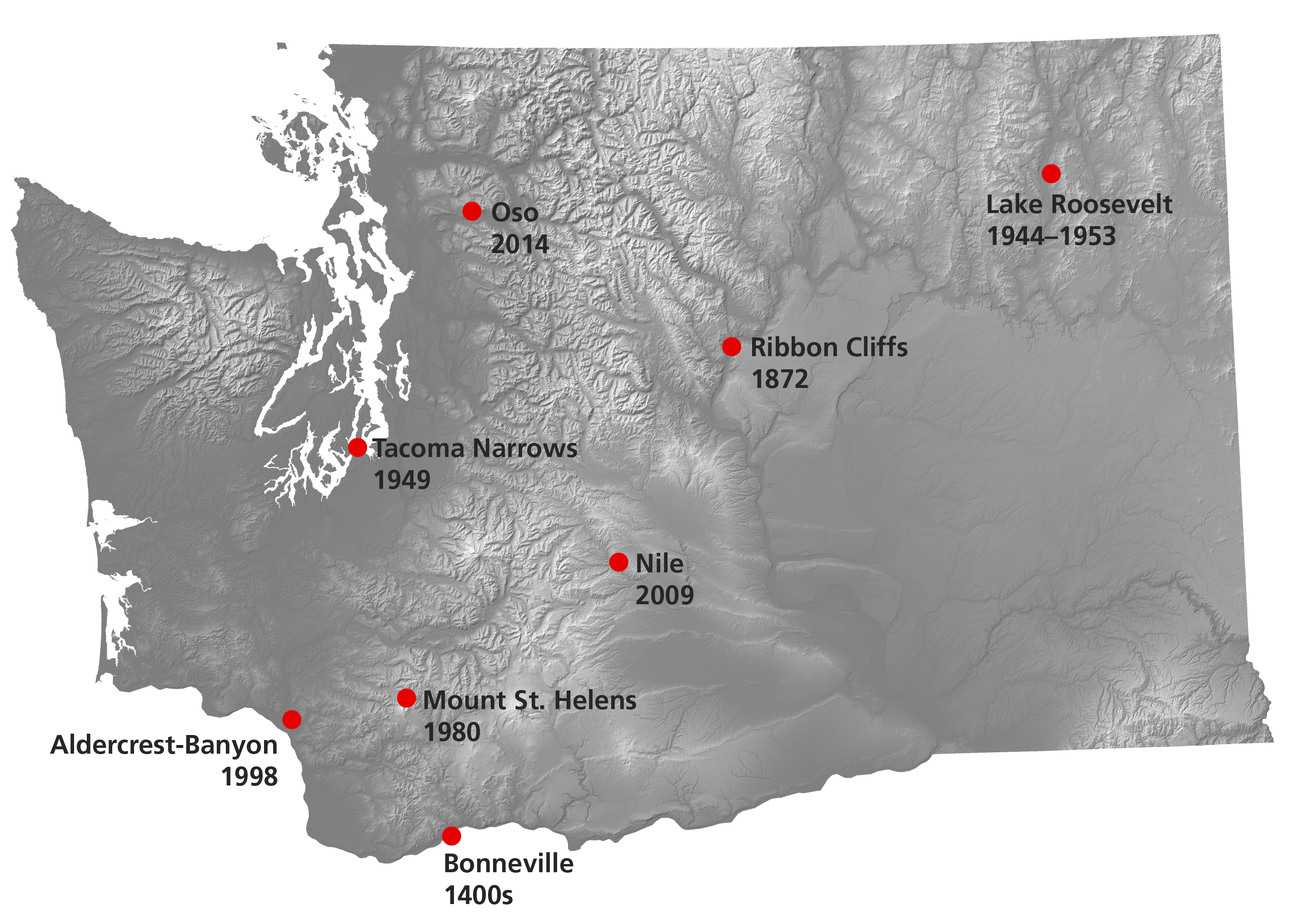
Washington has a long history of impactful landslides that have caused extensive damage and loss of life. The worst landslide in Washington state history was the 2014 Oso landslide, which tragically claimed 43 lives. Numerous other landslides have destroyed roads, homes, and caused hundreds of millions of dollars in damage. Many of the most impactful landslides occurred immediately after earthquakes or volcanic eruptions, such as a 1949 landslide that occurred after a magnitude 7.1 earthquake and then triggered a tsunami at Gig Harbor and Sunset Beach. The following is a list of especially noteworthy landslides that have impacted Washington state.


- SR 530 (aka Oso or Hazel)—Mar. 2014
- Nile—Oct. 2009
- Aldercrest–Banyon—Feb–Oct. 1998
- Mount St. Helens—May 1980
- Lake Roosevelt—1944–1953
- Tacoma Narrows—Apr. 1949
- Ribbon Cliffs—Dec. 1872
- Bonneville—mid-1400s
- Resources
-
Washington Geological Survey
Homeowner's Guide to Landslides—English The Homeowner's Guide to Landslides for Washington and Oregon provides information about how to prepare for landslide risk, how to detect landslides, and what to do in the event of a landslide emergency. Guía para Propietarios de Viviendas sobre Deslizamientos de Tierra Fact Sheet: What Are Landslides? This fact sheet explains the physics of landslides and describes landslides types. Fact Sheet: Landslide Hazards This fact sheet explains common landslide triggers, outlines landslide warning signs, and provides recommendations for reducing landslide risk. The Geologic Information Portal is an interactive web map interface for accessing geologic mapping in Washington, including landslide inventories and landslide susceptibility maps. Geologic Risk Pamphlet—English The Geologic Risk Booklet for Washington provides information about geologic risk including landslides, volcanoes, and tsunamis Landslides of Mount St. Helens Activity Book The Landslides of Mount St. Helens Activity Book provides information about landslides at the volcano and interactive activities to practice your landslide knowledge. WGS Geologic Planning Page In Washington State, the most significant geological hazards are earthquakes, tsunamis, volcanic events, and landslides. As part of the Growth Management Act (GMA), city and county jurisdictions must use best available science to identify the critical areas in their jurisdictions. Critical areas include geologically hazardous areas. The geologically hazardous areas as defined by the Washington Administrative Code (WAC) 365-190-120 include but are not limited to erosion, landslide, seismic, volcanoes, tsunamis, debris flows, and mine hazards. Washington Geologic Hazards Clearinghouse The Clearinghouse is a place for earth scientists, emergency managers, engineers, and other professionals representing various state agencies, federal bureaus, universities, and other interested public or private institutions to coordinate data collection and dissemination after a geologic hazard event. WGS Page Listing Geotechnical Consultants All regulatory agencies are required to provide upon request a list of organizations, including private companies, which can provide technical assistance (RCW 43.05.020). This page is a partial list of organizations and does not constitute an endorsement by any agency or organization. Washington State Forest Practices Board Manual Evaluating Unstable Slopes This PDF provides general practitioners with tools to understand landslide hazards in the areas of proposed forest practices activities, identifies when a qualified expert is needed, assists qualified experts with tools and methods to conduct geotechnical investigations, and provides guidance to prepare geotechnical reports. Emergency management and planning
Washington Emergency Management This page provides contact information for the Washington Emergency Management Division. The website also offers information about preparedness, disaster assistance, and updates on current disasters. Municipal or County Emergency Planning The Municipal Research and Services Center of Washington Emergency Management page provides resources and examples relating to emergency planning, emergency declarations and authorities, and emergency communication services. United States Geological Survey
Landslide Hazards Program The primary objective of the National Landslide Hazards Program is to reduce long-term losses from landslide hazards by improving our understanding of the causes of ground failure and suggesting mitigation strategies. This website provides resources on landslide science and preparedness. Washington State Agencies
Department of Ecology Page on Coastal Landslides This page includes information on coastal landslide preparedness including detailed guides for coastal bluff property owners on slope stabilization using vegetation and water management to improve slope stability. Road closures This interactive web map from the Washington State Department of Transportation (WSDOT) includes active road closures, incidents, and live traffic flow. Federal Emergency Management Agency (FEMA)
Landslides & Debris Flows This page offers general information on what to do before, during, and after a landslide, including information on how to get help from FEMA if you are a disaster survivor. - Frequently Asked Questions
-
Where do landslides occur?
Landslides can occur on gentle to steep slopes but they are most common on steep slopes.
When do landslides occur?
Landslides occur when the strength of material on a slope becomes less than the force of gravity acting on the material.
Who do I contact if there is a landslide?
Contact your city, county, or tribal Emergency Manager.
Washington Emergency Management This page provides contact information for the Washington Emergency Management Division. The website also offers information about preparedness, disaster assistance, and updates on current disasters. Municipal or County Emergency Planning The Municipal Research and Services Center of Washington Emergency Management page provides resources and examples relating to emergency planning, emergency declarations and authorities, and emergency communication services.