Subsurface geology is the study of the physical properties and location of rock and soil found below the ground surface. One of the most valuable reasons for learning about the subsurface is understanding the materials below man-made structures. These studies are commonly called geotechnical reports and are critical for building structures safely in areas with geologic hazards.
The importance of subsurface geology
If a proper subsurface geologic study was conducted in the year 1360, the Leaning Tower of Pisa would just be known as the Tower of Pisa today! These studies can also reveal hazards such as underground coal mine workings and unstable slopes. It is significantly cheaper to design for hazards than to repair the damage later. Thus, engineering companies often obtain geotechnical reports before starting any major project.
The construction industry relies heavily on mining sand and gravel resources. These resources provide the raw materials needed to produce concrete and asphalt for our roads, offices, and homes. Understanding the amount and quality of the sand and gravel in a resource deposit can influence many decisions in the mining process. Total reserve estimates, mine design, and mining method all depend on having quality subsurface data.
Subsurface studies are very important for understanding and protecting groundwater aquifers in order to maintain a steady supply of clean water. The U.S. Geological Survey and Washington State Department of Ecology have published many studies related to aquifers and their use. These studies help us understand how water flows through and is stored in aquifers as well as how contaminants may enter an aquifer. This allows people to plan future development so that aquifers remain viable for years to come.
Subsurface studies can also provide critical inputs for imaging magma chambers, geothermal exploration, locating active faults (paleoseismology), oil and gas exploration, carbon sequestration, and metal mining.
How is subsurface information collected?
There are several methods available to collect subsurface information. There are depth and resolution limitations associated with each method. Thus, knowledge of the limitations of each method is critical in undertaking a subsurface survey.
- Boreholes
- Ground penetrating radar
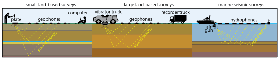
- Active seismic surveys
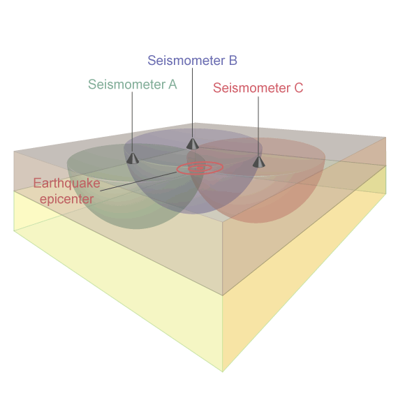
- Passive seismic surveys
- Gravity and magnetics
-
Drilling boreholes is the primary way used to obtain subsurface information. Drilling brings soil and rock to the surface for direct study. These materials are described on site and may also be sent to a laboratory for additional study. Information obtained from drilling includes material properties, changing rock or soil type, fault locations, and depth to water or bedrock. Tests can also be performed within open boreholes, to better understand the materials in place.
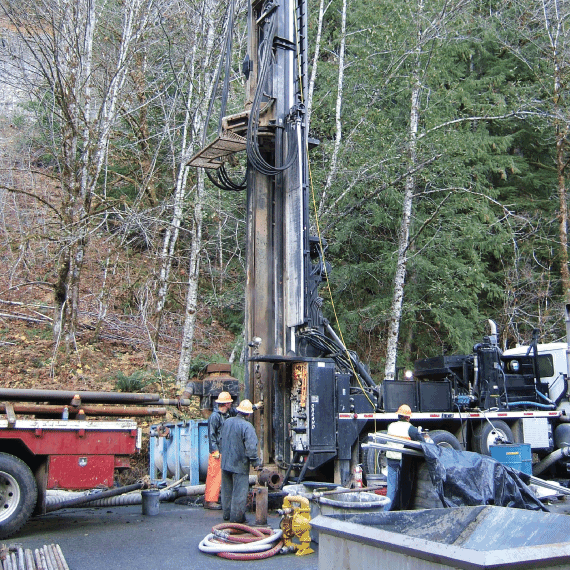
Geothermal core hole drilling in Snohomish County, 2012.
What We Do
The Washington Geological Survey maintains a state-wide database of many types of subsurface data. Survey geologists use this data to develop and produce resource maps, to help constrain the subsurface interpretation of geologic maps, to better understand faults and earthquakes, and to produce 3D models of the geology. The subsurface data also contain the locations and information for water wells, geotechnical borings, oil and gas wells, and geothermal wells. The centralization of these data represents a significant effort that benefits the entire geologic and geophysical community in Washington.
Get Our Data
The Washington Geological Survey produces reports, maps, and data with subsurface information. The majority of this information is available as GIS data and through our Geologic Information Portal. Check out our Publications and Data page to search for specific reports or maps.