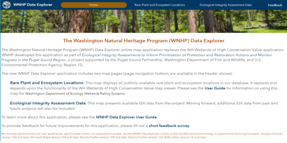
WNHP Data Explorer
The Washington Natural Heritage Program (WNHP) Data Explorer online Geographic Information System (GIS) application (see User Guide) replaces the WA Wetlands of High Conservation Value (WHCV) map viewer. Whereas the WHCV viewer primarily displayed wetland-associated rare species and ecosystems, the Data Explorer shares:
- All publicly-available locations of rare species and rare & high-quality ecosystems, known as Element Occurrences (EOs), currently documented in WNHP’s database, with precise species boundaries masked to protect sensitive species locations; and
- WNHP’s available Level 1 and Level 2 Ecological Integrity Assessment (EIA) data.
Other datasets are also accessible in the Data Explorer to help guide land use decisions, inform natural resource management, and prioritize conservation actions. We created the new Data Explorer using Esri’s ArcGIS Experience Builder platform built on the ArcGIS API for JavaScript 4.x technology. WNHP will continue to improve and expand the application into the future.
Background
WNHP developed this application as part of the Ecological Integrity Assessments to Inform Prioritization of Protection and Restoration Actions and Monitor Progress in the Puget Sound Region. The project was completed with funding from Puget Sound National Estuary Program in support of Near Term Actions 2018-0652 and 2018-0692 (WDFW Project 20-15677 / EPA Award No. PC-01J22301 / NTA 2018-0652 and 2018-0692).
[Read more]
Data Explorer Application Pages
The new WNHP Data Explorer application currently includes three pages.
- The Home Page
- The Rare Plant and Ecosystem Locations map
- The Ecological Integrity Assessment Data map
Home Page
The Home Page includes descriptions of the map pages and links to documentation and WNHP information.
Rare Plant and Ecosystem Locations
The Rare Plant and Ecosystem Locations map displays all publicly available rare plant and ecosystem locations in our database. It replaces and expands upon the functionality of the previous WA Wetlands of High Conservation Value map viewer.

WNHP maintains a database of rare species and rare and high-quality ecosystems for the state. The Rare Plants and Rare & High-quality Ecosystems layers in this map represent the Element Occurrence (EO) records that form the core of the Natural Heritage database (see Natural Heritage Methods). EOs include information on the location, status, characteristics, numbers, condition, and distribution of elements of biological diversity using established Natural Heritage Methodology developed by NatureServe and The Nature Conservancy.
Element Occurrences
An Element Occurrence (EO) is an area of land and/or water in which a species or natural community is, or was, present. An EO should have practical conservation value for the element as evidenced by potential continued (or historical) presence and/or regular recurrence at a given location. For species elements, the EO often corresponds with the local population, but when appropriate may be a portion of a population or a group of nearby populations (e.g., metapopulation). For ecosystem elements, the EO may represent a stand or patch of an ecosystem type, or a cluster of stands or patches of an ecosystem type.
An EO record is a data management tool that has both spatial and tabular components including a mappable feature and its supporting data. EOs are represented by bounded, mapped areas of land and/or water. EO records are most commonly created for current or historically known occurrences of natural communities or native species of conservation interest. They may also be created, in some cases, for extirpated occurrences.
The Known Rare Plants and Rare & High-quality Ecosystems layer includes EOs observed within the last 40 years. The Historical Rare Plants and Rare & High-quality Ecosystems layer includes EOs last observed 40+ years ago, as well the lowest precision records.
For further information concerning EO data, please see our EO GIS metadata document.
[Read more]
Reference Standard Wetlands
Locations of Reference Standard Wetlands are also included in the Data Explorer. Reference Standard Wetlands are considered to be among the best examples of specific wetland types. These wetlands are generally located in areas with long-term protection status. Reference standard wetlands need to be anchored to a specific classification scheme and specific ecological condition criteria. Here, wetland Subgroups are used as the classification standard and ecological integrity (as measured by the EIA method) as benchmark conditions. Reference standard wetlands shown in the Data Explorer reflect ecological conditions representative of wetlands with minimal human-induced disturbance and/or the best quality wetlands for a given type remaining on the landscape. These reference standard wetlands can be used to identify restoration potential and benchmarks, mitigation performance standards, conservation priorities, or to provide benchmark data to help understand how wetlands respond to human-induced disturbance.
[Read more]
Using the Data Explorer for Washington Department of Ecology Wetlands Rating Systems
A common use of WNHP’s EO data is for implementation of the Washington Wetland Rating System (Hruby, T. 2014a, 2014b, or as revised). In 2017, WNHP launched the Wetlands of High Conservation Value (WHCV) map viewer to assist users with the rating system.
The Washington Department of Ecology (Ecology) Wetland Rating Systems are tools designed to differentiate between wetlands based on their sensitivity to disturbance, rarity, our ability to replace them, and the functions they provide. They are designed to help agencies make decisions about standards for protecting wetlands. Ecology uses the term Wetland of High Conservation Value (WHCV) to describe a wetland that supports rare species or a rare or high-quality ecosystem type. These are known locations of any plant, nonvascular species, or ecosystems considered to be Endangered, Threatened, or Sensitive; or ecosystems prioritized by the WNHP based on a combination of the plant community type’s rarity or risk of extinction and its current ecological integrity. All wetlands that overlap occurrences of rare species or rare ecosystem types, regardless of their condition, are considered to be WHCV, while occurrences of wetlands with common ecosystem types are WHCV only if they are in good to excellent condition, as determined by the WNHP (e.g., high-quality ecosystems).
The WNHP Data Explorer displays known rare plants and rare and high-quality ecosystems. If any part of a wetland overlaps data from any of those layers, regardless of the plants’ wetland indicator status, the wetland meets the criteria for WHCV in the Washington Wetland Rating Systems, and that wetland is a Category I. By categorizing these wetlands as Category I, Ecology is trying to provide a high level of protection to these important and rare wetlands. These natural systems and species will survive in Washington only if we give them special attention and protection.
The WNHP Data Explorer is replacing and expanding on the functionality of the WHCV map viewer. As such, the WHCV map viewer will be retired and eventually removed from the WNHP web site. The WHCV map viewer only presented rare & high-quality wetland ecosystems while the Data Explorer includes all ecosystem EOs in WNHP’s database. While the WHCV map viewer did present all rare plant data, the names of the plants were masked. Rare plant names are included in EO records presented in the Data Explorer.
Not every wetland in Washington has been visited by WNHP staff; additional sites may contain rare species and/or rare & high-quality ecosystems that meet EO data standards. If you believe you've discovered a new location for a vascular plant or nonvascular species considered to be Endangered, Threatened, or Sensitive by our program, or discovered a rare or high-quality wetland ecosystem type, then see the 'Submitting Data to the Natural Heritage Program' section on our Data Products and Requests page. WNHP scientists will review submitted data to determine whether the species or communities meet the standard for a new EO. The accuracy of the boundaries of each EO varies depending on the quality of underlying data. Within the EO metadata , see 'Precision Code' for clarification.
Literature Cited
Hruby, T. 2014a. Washington State Wetland Rating System for Eastern Washington: 2014 Update. Publication #14-06-030. Olympia, WA: Washington Department of Ecology
Hruby T. 2014b. Washington State Wetland Rating System for western Washington. 2014 update. Washington State Department of Ecology, Olympia, WA. Publication #14-06-29.
[Read more]
Ecological Integrity Assessment Data
The Ecological Integrity Assessment Data map presents available EIA data from the project . We will include additional EIA data from past and future projects over time.
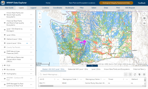
Ecological Integrity Assessments (EIAs) were developed by the Washington Natural Heritage Program (WNHP) and others to measure the ecological condition of upland and wetland ecosystems using standardized metrics to categorize sites into condition classes (Faber-Langendoen et al. 2019; Rocchio et al. 2020a,b).
[Read more]
Literature Cited
Citation Information
When using the Data Explorer as a source in reports and publications, please acknowledge the use of the application with the following citation information:
Washington Department of Natural Resources. 2023. Washington Natural Heritage Program Data Explorer. Washington Department of Natural Resources, Natural Heritage Program. Olympia, WA. Online: https://experience.arcgis.com/experience/174566100f2a47bebe56db3f0f78b5d9/. (Date viewed).