

Since its creation in 1890, the Washington Geological Survey has released over 1,000 publications and maps. Publications contains everything that we produce, from reports to maps. Maps contains a collection of all of our map-based publications only.
We announce the release of publications and other news through our blog, Washington State Geology News. If you'd like to receive notification when we publish something new, you can subscribe by email on the blog, or directly here.
Looking for our booklets, fact sheets, and posters? See a list with download links here.
Publications
|
WGS Publication Catalog |
Publications List |
Washington Geology Library |
NGMDB |
WGS Publication Catalog
|
The publication catalog lets you find anything that we have ever made since 1890. The catalog also provides a map that shows where each publication is located and a preview of the PDF. |
|
Publications List
Our downloadable Publications List contains all of our publications with links to their PDFs. The publications are listed in chronological order within each series. If you don't know the series and number, you can search the publications list using Ctrl+F (Find).
Washington Geology Library
|
The Washington Geology Library Online Catalog is a collection of all publications, regardless of publisher, having to do with Washington geology. There are over 80,000 items in the library and more are added every year. |
|
National Geologic Map Database
|
The National Geologic Map Database (NGMDB) is a congressionally mandated project led by the U.S. Geological Survey and Association of American State Geologists. The purpose is to build a national archive of maps and related data about geology, hazards, earth resources, geophysics, geochemistry, geochronology, paleontology, and marine geology. You can access it through a searchable catalog that contains information on over 88,000 geoscience maps and reports dating back to the 1800s, with links to hundreds of publishers. |
Maps
|
Geologic Maps |
Geologic Hazard Maps |
Resource Maps |
Washington Geologic Information Portal |
Geologic Maps
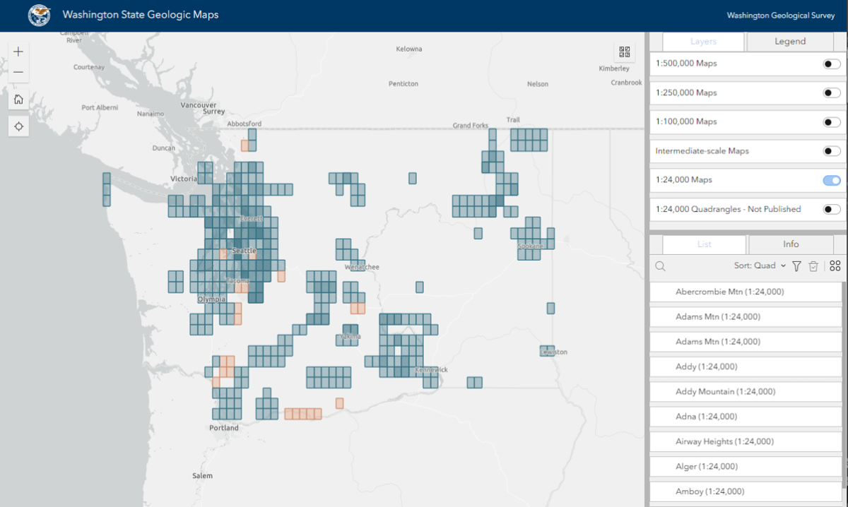
Surface Geology Maps
Vist our Washington State Geologic Map application to find surface geology maps throughout the state. Use the interactive filter and search tools to find geologic maps based on location and scale.
Google Earth Overlays
Click on the map below to download 1:100,000-scale geologic map KMZ files for use in Google Earth

Click here to open the map in full screen.
Instructions for KMZ Files
Download the instructions, or watch the following YouTube video:
Geologic Hazard Maps
- Tsunami evacuation
- Tsunami inundation
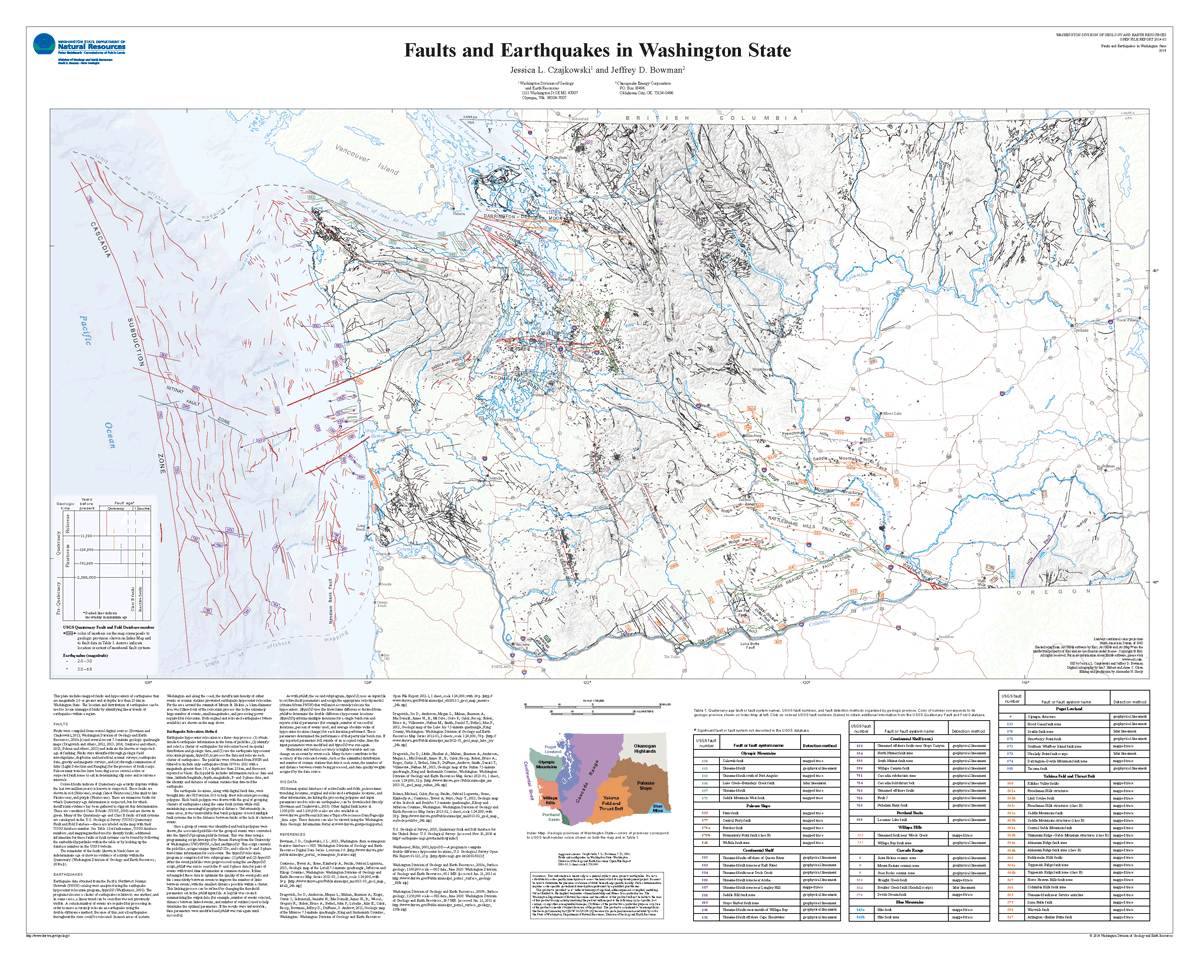
- Active faults and earthquakes
- Seismic scenarios
- NEHRP site class and liquefaction susceptibility
- Seismic design categories
- Hazardous minerals
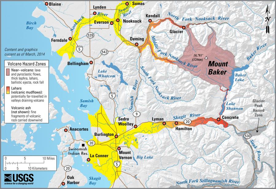
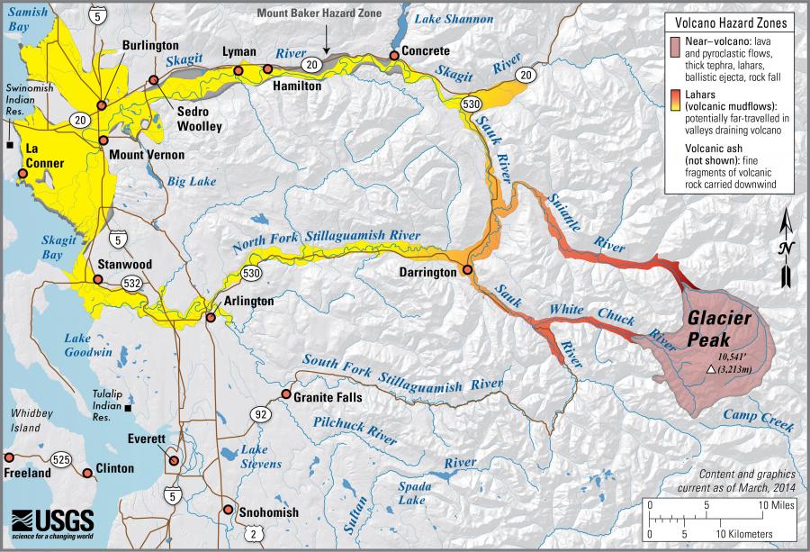
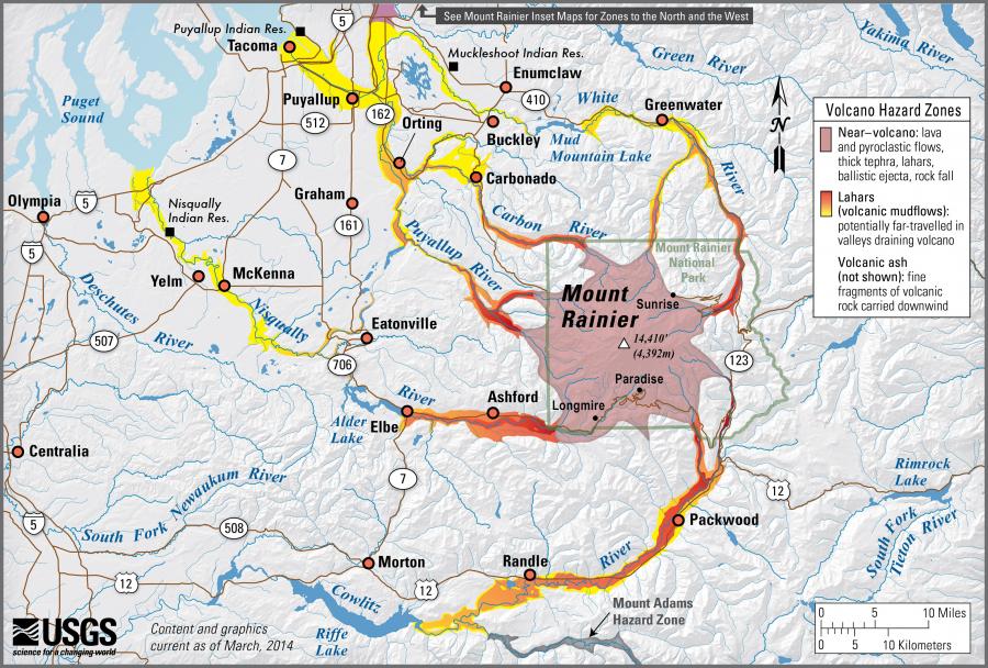
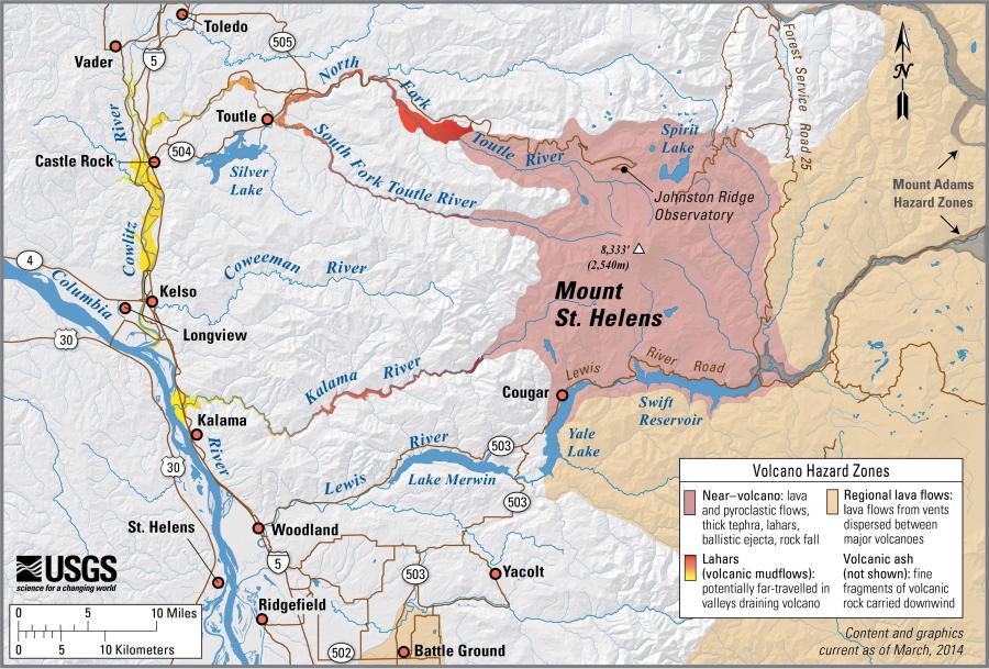
- Lahar hazards
- Landslides
- Inactive and abandoned mines
-
Tsunami evacuation routes were developed to assist coastal residents and visitors find safer locations in case of an earthquake and tsunami. The published brochures are for specific areas.
The Geologic Information Portal has a Tsunami Evacuation single-topic map that allows you to search for addresses and locations of interest. The information on the portal and in the brochures is the same.
Evacuation Maps
This map shows all completed tsunami evacuation brochures and walk time maps for Washington. Clicking on a region will show you a link to download the map product. Use your scroll wheel or the zoom buttons in the upper left corner to zoom. For more information about these maps, visit our tsunami webpage.
Click on the areas of the map below to view and download walk time maps (in purple) and evacuation brochures (in green).
Click here to open the map in full screen.


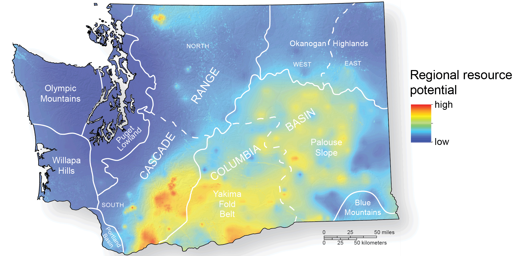
Resource Maps
- Aggregate resources
- Oil and gas resources
- Geothermal resources

Geologic Information Portal
|
We have converted much of the State's geologic mapping at multiple scales to a digital format. Explore geologic maps, geologic hazard data, and earth resource information for your neck of the woods. |
|
