
Washington State's adoption of the 2018 and 2021 International Building Code (IBC) included amendments to the original code language to direct designers, engineers, and architects to use Washington Tsunami Design Zone (WA-TDZ) maps, where available, to determine whether structures in Risk Categories III or IV need to be designed for tsunamis.
Specifically, the code requires that certain tsunami-related design parameters be considered if a structure is located in an tsunami inundation area as mapped in the WA-TDZ. Additionally, any site-specific tsunami inundation studies must use WA-TDZ offshore amplitude data points as a baseline in their analysis. In support of these code requirements, the Washington Department of Natural Resources (DNR) maintains a series of WA-TDZ maps on this webpage.
Below you will find the 2018 and 2021 WA-TDZ maps. The 2021 WA-TDZ went into effect March 15, 2024. Both the 2018 and 2021 WA-TDZs feature an interactive map where users can access site-specific information, as well as links to download the original map publications that are cited in the respective building codes. The interactive map and source publications include tsunami inundation extent (runup), inundation elevation, and maximum current velocity.
2021 Tsunami Design Zone
We recommend users jump to their project site or zoom in to an area of interest by using the search tool in our WA-TDZ interactive map (click the picture below to access the map).
The interactive map contains:
- Tsunami inundation extent—a polygon displaying the maximum modeled extent of tsunami inundation as published in the WA-TDZ.
- Tsunami inundation elevation in feet—Elevation of the maximum modeled tsunami inundation over the Mean High Water datum.
- Tsunami current velocity in feet per second—Maximum velocity from the tsunami inundation model.
- Tsunami studies—Extent of the source publications used in this map with provided citations and hyperlinks to the publications and digital datasets provided.
- Tsunami offshore points—Simulated tide gauges (showing amplitude in feet and period in minutes) created at the approximate 100-meter depth contour for use in comparative analysis of site-specific tsunami models or new or revised regional tsunami models.
While viewable at all scales, the identify pop-up is best used when zoomed in, or else you may accidentally select multiple adjacent data polygons.
Access the 2021 interactive map
User Note: This Washington Tsunami Design Zone (WA-TDZ) interactive map contains a lot of data and may take time to load. The intent is for this map to be used at the specific location you are interested in, so please zoom before clicking. We recommend zooming in until the scale shown in the bottom left corner reads “100 ft.” If your site is located within a mapped tsunami inundation area (indicated by a yellow overlay) then it is located within the WA-TDZ. Click within the yellow WA-TDZ area to find values for maximum tsunami inundation elevation and maximum current velocity, and further information about the study area, download options. Click offshore points to see offshore amplitude data.
Building Codes
Washington State's adoption of the 2021 International Building Code (IBC) included an amendment to adopt the ASCE 22 7-22 tsunami loads chapter with amendments that direct designers, engineers, or architects to use the Washington Tsunami Design Zone Maps (WA-TDZ) to determine whether structures in Risk Category III or IV need to be designed for tsunamis. Special design parameters must be considered for these structures if they are located in the WA-TDZ. Further, the code requires the use of Washington DNR Tsunami Inundation Data for design purposes, or that such data be considered as a baseline for self-conducted studies. Please consult the 2021 Washington State Building Code for official language.
Datums Used in the 2021 Inundation Calculation
Note that while the 2018 WA-TDZ maps were relative to the North American Verical Datum of 1988 (NAVD88), the 2021 WA-TDZ models inundation relative to a mean high water (MHW) tidal datum as required by the building code.
All WA-TDZ products incorporate ground deformation (subsidence) from the earthquake in the inundation depth elevation results. Be aware that the products on this page do not include any contribution from sea level rise. Local sea level rise projections for Washington State are available here: Miller and others, 2018.
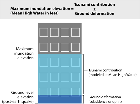
The final inundation elevation is the combination of land level subsidence and inundation depth.
2021 WA-TDZ Publications
| Maps adopted for the 2021 Tsunami Design Zone | ||
|---|---|---|
| Location | Publication | Link |
| Columbia River | DOGAMI SP-51 | Download |
| Outer Coast and Strait area | MS 2022-01 | Download |
| Port Angeles and Port Townsend area | MS 2018-03 (Partially superseded by MS 2022-01) | Download |
| Puget Sound | MS 2021-01 | Download |
| San Juan Islands | MS 2016-01 (Partially superseded on its eastern edge by MS 2021-01) | Download |
| Southern Washington coast | MS 2018-01 | Download |
Download 2021 WA-TDZ GIS Data
Click here to download a zip file (115 MB) that contains a geodatabase with the feature classes used in the interactive map above.
2018 Tsunami Design Zone
| Maps adopted for the 2018 Tsunami Design Zone | ||
|---|---|---|
| Location | Publication | Link |
| Anacortes and Bellingham area | MS 2018-02* | Download |
| Elliott Bay Seattle | OFR 2003-14 | Download |
| Everett area | OFR 2014-03 | Download |
| Port Angeles and Port Townsend area | MS 2018-03 | Download |
| San Juan Islands | MS 2016-01* | Download |
| Southern Washington coast | MS 2018-01 | Download |
| Tacoma area | OFR 2009-9 | Download |
*Designers wishing to use the latest maps can find them here.
Datums Used in the 2018 Inundation Calculation
Please note that inundation depth values quoted in both source publications and raw data available from WA DNR are relative to a mean high water (MHW) tidal datum. As this is higher than the standard North American Vertical Datum of 1988 (NAVD 88) used in the IBC, the values listed in the WA DNR data will need to be recalculated according to the differences between NAVD 88 and MHW at the project site. This recalculation to NAVD88 has already been conducted for the data displayed in the map below. The 2018 WA-TDZ maps, model data, and results within the 2018 WA-TDZ interactive map already incorporate ground deformation (subsidence) from the earthquake in the inundation depth/elevation results. The published maps, model data, and results shown here do not include any contribution from sea level rise. Local sea level rise projections for Washington State are available here: Miller and others, 2018.
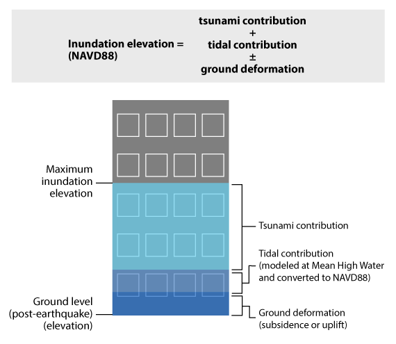
The finalized inundation elevation is the combination of land level subsidence, MHW conversion, and inundation depth.
We recommend users click the search tool in the webmap below (click the picture below to access the map in fullscreen) to jump to their project site or zoom in to an area of interest. While viewable at all scales, the identify pop-up is best used when zoomed in, or else you may accidentally select numerous adjacent data.
Access the 2018 interactive map
Use limitations
Disclaimer of Warranties. No express or implied warranty of any kind is made regarding the functionality of the interactive map or the information contained therein, including, but not limited to, the warranty of merchantability, warranty of fitness for a particular purpose, or warranties of content, completeness, accuracy, reliability, usefulness, or that use would not infringe on privately-owned rights. Although these digital data and metadata have been processed successfully on computers of WGS, no warranty, expressed or implied, is made by WGS regarding the use of these data on any other system, nor does the fact of distribution constitute or imply any such warranty.
Use at Your Own Risk. The information obtained through this interactive map is only intended to help qualified professionals, such as designers, engineers, and architects, determine which structures in Risk III or IV Categories need to be designed for tsunami loads and the respective baseline inputs to design calculations under the Washington State Building Code.
Limitation on Liability. User agrees there shall not be any liability on the State of Washington, Washington Department of Natural Resources, or their officers, agents, representatives, or employees for any damages allegedly resulting from any use or misuse of this information/product. Under this limitation, there shall be no liability for any damages whatsoever, including but not limited to any damages in contract or tort for compensatory, consequential, punitive, direct, indirect, or special damages such as personal injuries, property damage, loss of profits, or any other losses or expenses.
No Endorsement. Reference herein to any specific commercial product, process, or service by trade name, trademark, manufacturer, or otherwise, does not constitute or imply its endorsement, recommendation, or favoring. Further, the views and opinions of authors expressed herein do not necessarily state or reflect those of the State of Washington or any agency thereof.
