Mount Si Natural Resources Conservation Area
|
|
Attention: Alerts and Closures
There are no recreation alerts at this time. Please check back for more information in the future.
|
|
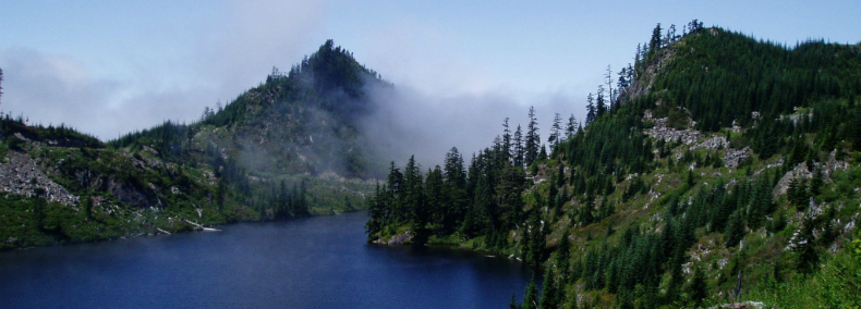
The Mount Si Natural Resources Conservation Area (NRCA) was one of the first to be established in 1987. It was designated to protect numerous natural resources including outstanding geologic features, examples of old growth forest, wildflower communities, and habitat for mountain goat and other species of wildlife. The towering site is a scenic landmark and popular recreation area, offering views of the Olympic Mountains, Snoqualmie Valley, and the Cascade Mountains. The NRCA is 13,735 acres.
There are four mountain peaks in Mount Si NRCA, including Mount Si, Mount Teneriffe, Green Mountain, and Little Si. The expansive, primarily forested terrain supports some significant plant communities. Unique high-elevation Sitka spruce stands occur in two distinct locations. Also at upper elevations, Pacific silver fir and mountain hemlock dominate old-growth forests over 200 years old. Subalpine meadows, grasslands on mountain ridges, and rock outcrops are fragile areas inhabited by wildflower communities and the state sensitive clubmoss cassiope.
Several stream systems originate in Mount Si NRCA and eventually drain into the Middle Fork or North Fork Snoqualmie River. Most contain small streams running down steep ravines. The ecologically rich streambanks provide habitat for boreal bedstraw, a state sensitive plant species.
Three alpine lakes, Lake Moolock, Lake Nadeau, and SMC Lake, are closely situated in the remote northeastern conservation area. Crater Lake and Rachor Lake are smaller subalpine lakes with wetland components. The shallow Crater Lake has a large wetland area dominated by bladder sedge, while Rachor Lake sustains peripheral wetland vegetation such as skunk cabbage and bluejoint reedgrass.
Features protected: old-growth Douglas fir, mountain hemlock, western hemlock forests, outstanding geologic features, a high elevation Sitka spruce forest, wetlands and lakes, rock outcrops, cliffs, grasslands and riparian areas. It provides important habitat for native mountain goats that use the steep cliffs, black bear, elk, deer cougar and coyote.
Ecoregion: Puget Trough (King County)
Ecoregion: Puget Trough (King County)
Science, Research and Monitoring
Public and private universities, other research institutions and individual researchers may contact DNR to propose a research project at the site. If you are interested in pursuing research at Mount Si NRCA, please contact David Wilderman, Natural Areas Ecologist, at david.wilderman@dnr.wa.gov
- Mt. Si Vascular Plant Inventory (230KB PDF)
Volunteer and Stewardship Opportunities
If you are interested in volunteer and stewardship opportunities at Mount Si NRCA, please contact the South Puget Sound Region Natural Areas Manager.
Environmental Education and Public Access
The trails on Mt. Si offer an excellent outdoor classroom and they are convenient and accessible to many school communities in the Puget Sound region. Two miles up the Mount Si Trail at what is known as Snag Flats is an interpretive display. There is a short boardwalk trail with interpretive panels that explain the ecology of the NRCA and older forest ecosystems. The Frances North Loop Trail at the base of the Mount Si Trail is a .2 mile barrier-free trail that crosses a stream in two locations.
Trail Maps
- Mount Si Trail Map
- Oxbow Loop Trail Map
- Mount Si NRCA Boundary Map
You can find more detailed information about the trails in the Mount Si NRCA at Green Trails Maps.
The Mount Si NRCA Management Plan and the Mount Si NRCA Public Use Plan provide detailed information about natural resources present within the NRCA and appropriate use of the site. For more information, contact the South Puget Sound Region Natural Areas Manager.
- Dogs allowed on leash.
- Garbage service is not provided. Pack out what you pack in.
- Day use only.
Restoration at Mount Si NRCA
In 2005 and 2006, Washington Department of Natural Resources partnered with Mountains to Sound Greenway Trust (MTSGT) to completely renovate the Mt. Si Trail. Decades of hiking were beginning to take its toll on the popular trail, with erosion damaging natural resources. Mountains to Sound Greenway Trust, in cooperation with volunteers completely renovated the trail creating a safer and more enjoyable hiking experience.
Directions to Mount Si NRCA Trailhead
Traveling either east or west on Interstate 90, take Exit 32 at North Bend. Turn north (toward Mount Si) onto 436th Avenue. At the “T” intersection, turn left onto North Bend Way. In one-third of a mile, turn right onto Mt. Si Road. The Mount Si trailhead is in approximately 2.5 miles on the left.
Directions to Little Si Trailhead at Mount Si NRCA
Traveling either east or west on Interstate 90, take Exit 32 at North Bend. Turn north (toward Mount Si) onto 436th Avenue. At the “T” intersection, turn left onto North Bend Way. In one-third of a mile, turn right onto Mt. Si Road. Shortly after crossing the bridge over the Middle Fork Snoqualmie River, the road curves to the right and passes an overflow parking area, with the main parking lot located on the left just beyond the bend.
Directions to Mount Teneriffe Trailhead at Mount Si NRCA
Traveling either east or west on Interstate 90, take Exit 32 at North Bend. Turn north (toward Mount Si) onto 436th Avenue. At the “T” intersection, turn left onto North Bend Way. In one-third of a mile, turn right onto Mt. Si Road. The Mount Teneriffe trailhead is approximately 3 miles on the left, about a half-mile past the main Mount Si Trailhead.
A Washington State Discover Pass is required for parking at the Mount Si NRCA and the Little Si Trailhead at Mount Si NRCA. This funding helps DNR manage these important natural areas across the state.