
Home

Translate

Search form

  • Programs and Services
    • Aquatics »
      • Aquatic Leasing and Licensing »
        • Dredging
        • Mooring Buoys »
          • Quartermaster Harbor
          • Raft Island
          • Salmon Bay
          • Wollochet Bay
        • Ports
        • Harbor Areas
        • Bush and Callow Act Aquatic Lands Maps
        • Orca-Straits
        • Rivers District
        • Shoreline District
      • Aquatic Lands Restoration Team »
        • Aquatic Lands Habitat Restoration Program
        • South Lake Washington Restoration Project
        • Bird Island Shoreline Enhancement
        • McNeil Island Shoreline Restoration
        • Whiteman Cove Restoration
        • Marine Debris Removal Program
        • Deep Water Derelict Net Removal
        • Creosote Piling Removal Program
        • Maury Island Natural Area
        • Lakebay Marina Redevelopment
        • Tire Pile Removal Program
        • Dickman Mill Piling Removal
      • Recovering Derelict Vessels »
        • Bid on Removal Contracts
        • Derelict Vessel Background
        • Derelict Vessel Inventory
        • Notices of Intent
        • Vessel Requirements
        • Vessel Turn-In Program
        • Vessel Reporting
      • District and Land Manager Map
      • Aquatic Science »
        • Aquatic Assessment and Monitoring Team »
          • Data Sharing
          • Research and Monitoring
          • Scientific and Technical Support to Aquatic Programs
          • Scientific Review
          • Research Toolbox
          • AAMT Publications and Presentations
          • Climate Resilience and Community Science
        • Nearshore Habitat Program »
          • Eelgrass Data Viewer
          • Eelgrass Monitoring
          • Eelgrass Stressor Response
          • Kelp Monitoring
          • Kelp Research and Monitoring Workgroup
          • Statewide Kelp and Eelgrass Health and Conservation Plan
          • Marine Vegetation Atlas
          • Nearshore Habitat Inventory
          • Nearshore Habitat Monitoring
          • Nearshore Habitat Publications
          • Seagrass Restoration
          • Special Projects
      • Aquatic Stewardship »
        • Cypress Island Atlantic Salmon Pen Break
      • Aquatic Invasive Species
      • Enhancing Aquatic Lands
      • Seaweed Harvesting
      • Shellfish »
        • DNR Divers
        • Razor Clams
        • Aquaculture
        • Geoduck Aquaculture
        • Wild Geoduck Fishery
      • Watershed Resilience Program »
        • Snohomish Watershed Resilience Action Plan »
          • Forest Landowner Fish Passage Initiative (FloFish)
          • Large Wood Supply Initiative - Snohomish Pilot (LWSI)
        • Watershed Expansion
        • Watershed Resilience Action Plan
    • Engineering »
      • Forest Roads
    • Forest Resilience »
      • Forest Health Strategic Plan
      • Forest Action Plan
      • Prescribed Fire Program »
        • Certified Burner Program
      • Post-Fire Recovery Program
      • Financial Assistance for Forest Health
      • Forest Stewardship Planning
      • Wildlife Habitat and Forest Health
      • Insects and Disease Monitoring
      • Federal Lands Program
      • Urban and Community Forestry »
        • Anti-Tree Topping
        • Evergreen Washington
    • Forest Regulation »
      • Adaptive Management »
        • Research and Monitoring Documents
      • Compliance Monitoring
      • Cultural Resources
      • Forest Practices Application
      • Forest Practices Training
      • fpOnline »
        • FAQ
        • Newsletters
      • GIS Forest Practices Data
      • Habitat Conservation Plan
      • Review Applications (FPARS) »
        • Forms and Instructions
      • Small Forest Landowners »
        • Alternate Plans
        • Family Forest Fish Passage
        • Forestry Riparian Easement
        • Rivers and Habitat Open Space Program
        • Regulation Assistance for Landowners
    • Forest Resources »
      • Earth Sciences
      • Growing State Forests
      • Climate-Smart Forestry
      • Habitat Conservation »
        • Cultural Resources
        • HCP Publications
        • Marbled Murrelet »
          • Marbled Murrelet LTCS
        • Mature and Old Growth Forests
        • Monitoring and Reporting
        • Policy for Sustainable Forests
        • Riparian Forest Restoration
        • Spotted Owl
      • Olympic Experimental State Forest »
        • Location and Natural Environment
        • Forest Management
        • Research Program and Adaptive Management
        • Research and Monitoring Projects
        • Publications, Maps, and Data
        • Guidelines for Researchers
        • Outreach and Education
      • Sustainable Harvest Calculation »
        • 2025-34 Westside
        • 2025-34 Eastside
        • Previous Decades
      • Webster Forest Nursery »
        • Plant the Right Tree Seedling
        • Prices and Availability
    • Geology »
      • Publications and Data »
        • Booklets, Fact Sheets, and Posters
        • Disclaimers and Citation Guidelines
        • Past Releases
        • Publications and Maps
        • Geologic Information Portal »
          • Washington Geology App
        • Washington Geologic Survey Publications Catalog
        • GIS Data and Databases
        • Presentation Archive
        • Lidar
        • Story Maps
      • Geologic Maps »
        • Surface Geology
        • Subsurface Geology
      • Education and Outreach
      • Energy, Mining, and Minerals »
        • Rules, Regulations, and Forms
        • Geothermal Resources
        • Oil and Gas Resources
        • Coal, Metallic, and Mineral Resources »
          • Coal Maps
        • Surface Mining and Reclamation
        • Aggregate Resources
      • Environment »
        • Geologic Carbon Sequestration
        • Groundwater »
          • Hydrogeologic Modeling
      • Explore Popular Geology »
        • WA100 Geotourism
        • Geologic Provinces »
          • Okanogan
          • North Cascades
          • Southern Cascades
          • Olympic Mountains
          • Willapa Hills
          • Columbia Basin
          • Blue Mountains
          • Puget Lowland
          • Portland Basin
        • Puget Sound, Coastal Geology
        • Geology Glossary
        • Glacial Geology
        • Rockhounding
      • Frequently Asked Questions
      • Geologic Hazards »
        • Wildfire-Associated Debris Flows
        • Earthquakes and Faults »
          • School Seismic Safety
          • Seismic Scenarios
        • Landslides
        • Volcanoes and Lahars
        • Tsunami »
          • Tsunami Design Zone Maps for Washington State Building Code
          • TsuInfo
        • Geologic Hazard Maps
        • Hazardous Minerals
        • Emergency Preparedness »
          • Risk MAP
        • Washington Geologic Hazards Clearinghouse »
          • Clearinghouse Forms
      • Geologic Planning
      • Washington Geology Library
      • About the Survey
      • Contact Us
    • Landowner Assistance Portal
    • Maps and Surveys »
      • Public Land Survey Office
    • Natural Heritage Program »
      • WNHP Data Explorer
      • Data Products and Requests »
        • Wetlands of High Conservation Value Map Viewer
      • Ecosystems »
        • U.S. National Vegetation Classification
        • Ecological Systems
        • Wetland and Riparian Vegetation Types
        • Ecological Integrity Assessment
        • Floristic Quality Assessment
        • WA Invasive Ranking System
        • Reports
      • Rare Species »
        • Species Lists
        • Rare Plant Field Guide
        • Reports
      • Climate Change »
        • Assessing Species Vulnerability
      • Natural Heritage Methods
      • Conservation Planning
    • Natural Resources Police
    • Product Sales and Leasing »
      • Agriculture and Grazing »
        • Leases Offered at Public Auction
        • Leases Offered Through Re-Lease Negotiations
        • Lease Auction Results
        • Lease Opportunity Viewer
      • Timber Sales »
        • Timber Auction Packets »
          • January 2025 Timber Auction
          • February 2025 Timber Auction
          • March 2025 Timber Auction
          • April 2025 Timber Auction
          • May 2025 Timber Auction
          • June 2025 Timber Auction
          • July 2024 Timber Auction
          • August 2024 Timber Auction
          • September 2024 Timber Auction
          • October 2024 Timber Auction
          • November 2024 Timber Auction
          • December 2024 Timber Auction
          • Contract Harvester Bid
          • Early Timber Sale Previews
          • Unsold Sales Available at Minimum Value
          • Bidding Procedures & Forms
          • Timber Auction Dates
        • Timber Auction Results »
          • Timber Sale Remaining Volume by Purchaser Reports
        • Timber Sale Query/Log Prices
        • Previous Timber Auction Books
        • Forest Certification
        • Logger Safety Initiative
        • Biomass
      • Clean Energy »
        • Clean Energy Screening Tool
      • Commercial Real Estate »
        • Affordable Housing
      • Communications Towers »
        • Rural Broadband
      • Firewood
      • Land Appraisal Unit
      • Mining and Mineral Leases
      • Rights-of-Way
      • Brush, Salal and Other
      • Spanish - Brocha, Salal y Otros Productos Forestales
    • Recreation »
      • Recreation Openings
      • Where to go, what to do
      • Find your campsite
      • Using our mobile maps
      • Discover Pass
      • Recreation Planning & E-bikes »
        • Recreation Strategic Plan
        • Reiter Nonmotorized Trails Planning
        • Morning Star Trails Planning
        • Complete: Baker to Bellingham Non-Motorized Recreation Plan
        • Darrington Mountain Bike Trails
        • E-bike Rules and Regulations
        • Recreational Target Shooting
      • Volunteer
      • Puget SoundCorps
    • Wildfire »
      • Fighting Fire »
        • Aviation Program
        • Correctional Camps Program
        • Facilitated Learning Analysis
        • Fire Business »
          • DNR Radio Operations
        • Fire District Assistance
        • Firefighter Jobs
        • Provide Equipment and Services for Fire Suppression
        • Ways to Help
        • Wildfire Assessments
        • Wildland Fire Academies
      • Community Wildfire Resilience and Preparedness »
        • Community Wildfire Defense Grant
        • Community Wildfire Protection Plan Guidance
        • Community Wildfire Protection Plans
        • Community Wildfire Resilience Resource Library
        • Firewise USA® - Prepare Your Home
        • Wildfire Ready Neighbors
      • Current Wildfire Incident Information »
        • Investigations
      • Industrial Fire Precaution Level
      • Outdoor Burning »
        • Burn Permits
        • Burn Restrictions
      • Smoke Resources
      • Wildfire Prevention »
        • Wildland Fire Protection Strategic Plan
  • ABOUT
    • Calendar
    • Boards and Commissions »
      • Board of Natural Resources »
        • BNR Past Meetings
      • Forest Practices Board »
        • Rules and Guidelines »
          • Forest Practices Rules
          • Forest Practices Board Manual
          • Forest Practices Rule Making
          • Forest Practices Rule Archive
        • FPB Past Meetings
        • CMER Committee »
          • Past CMER Meetings
        • TFW Policy Committee »
          • TFW Policy Committee - Past Meetings
          • Forest Practices Board Key Water Typing Decisions 2016 to Current
        • Northern Spotted Owl
        • Water Typing Rule Committee »
          • Anadromous Fish Floor Work Group
      • Advisory Committee on Real Estate Strategy
      • Blanchard Forest Advisory Committee
      • Carbon and Forest Management Work Group »
        • Carbon and Forest Management - Past Meetings
      • Committee on Geographic Names
      • Ecosystem Services Work Group
      • Encumbered Lands Steering Committee
      • Environmental Justice Advisory Committee
      • Forest Health Advisory Committee
      • Lidar Advisory Committee
      • Natural Heritage Advisory Council
      • Small Forest Landowner Advisory Committee
      • Survey Advisory Board
      • State Mapping Advisory Committee
      • Surface Mine Advisory Committee
      • Sustainable Harvest Technical Advisory Committee
      • Teanaway Community Forest Advisory Committee »
        • Teanaway Community Forest Advisory Committee - Past Meetings
      • Trust Land Transfer Work Group and Advisory Committee
      • Utility Wildland Fire Prevention Advisory Committee »
        • Utility Wildland Fire Prevention Advisory Committee - Past Meetings
        • Utility Wildfire Mitigation Plans
      • Washington Community Forestry Council »
        • Washington Community Forestry Council - Past Meetings
      • Wildland Fire Advisory Committee »
        • Wildland Fire Advisory Committee - Past Meetings
    • Beneficiaries
    • Environmental Justice »
      • Environmental Justice Budget Equity
      • Environmental Justice Assessments
      • Healthy Environment for All (HEAL) Act
    • Fiscal Reports »
      • County Income Reports
      • DNR Annual Reports
      • Economic Forecasts
      • Mill Surveys
      • Timber Harvest Reports
    • Legislative Information
    • Wildfire, Forest & Community Resilience Account »
      • Climate Resilience for Washington
    • Request Public Records
    • Tribal Relations
    • Trust Land Performance Initiative »
      • Optimize Asset Portfolio
      • Revenue Reliability
      • Transaction Abilities
      • New Tools
      • Assessment
    • About Washington DNR
    • Spanish Resources - Recursos en Español
    • Youth Education »
      • Youth Education Portal
    • Contact DNR »
      • Regions and Districts
  • MANAGED LANDS
    • Forest and Trust Lands »
      • Ahtanum
      • Blanchard, Whatcom County and Nearby Islands
      • Capitol Forest
      • Elbe Hills and Tahoma
      • Green Mountain and Tahuya
      • Little Pend Oreille
      • Loomis and Loup Loup
      • Naneum Ridge
      • Olympic Peninsula
      • Reiter Foothills and Walker Valley
      • Teanaway
      • Tiger Mountain and Raging River
      • Klickitat Canyon
      • Yacolt Burn
    • Natural Areas »
      • Natural Resources Conservation Areas
      • Natural Area Preserves
    • Aquatic Reserves »
      • Cherry Point
      • Cypress Island
      • Fidalgo Bay
      • Maury Island
      • Nisqually Reach
      • Protection Island
      • Smith and Minor Islands
      • Lake Kapowsin
    • Land Transactions »
      • Trust Land Transfer »
        • Selecting a Parcel
        • Selecting a Receiving Agency
        • Preparing an Application
        • Eligibility Determination
        • Prioritization
        • The Advisory Committee
        • Transfer and Replacement
        • Proposed and Current Transfers
        • Success Stories
      • Frederickson Road-Trembley Exchange
      • Okanogan Parcel W Land Auction
      • Proposed Clearwater Land Exchange
      • Richland 16-Land Bank Exchange
      • Thorpe Land Exchange
    • Community Forest Trust
  • Working at DNR
    • Jobs »
      • Internships
    • Employee Well-Being
  • Commissioner
    • Commissioner Upthegrove
    • Commissioner's Orders
    • DNR's Strategic Plan
    • Executive Team
  • Programs and Services
    • Aquatics
      • Aquatic Leasing and Licensing
      • Aquatic Lands Restoration Team
      • Recovering Derelict Vessels
        • Vessel Turn-In Program
        • Notices of Intent
        • Derelict Vessel Inventory
        • Derelict Vessel Background
        • Bid on Removal Contracts
        • Vessel Requirements
        • Vessel Reporting
      • District and Land Manager Map
      • Aquatic Science
      • Aquatic Stewardship
      • Aquatic Invasive Species
      • Enhancing Aquatic Lands
      • Seaweed Harvesting
      • Shellfish
      • Watershed Resilience Program
        • Snohomish Watershed Resilience Action Plan
          • Forest Landowner Fish Passage Initiative (FloFish)
          • Large Wood Supply Initiative - Snohomish Pilot (LWSI)
        • Watershed Expansion
        • Watershed Resilience Action Plan
    • Engineering
      • Forest Roads
    • Forest Resilience
      • Forest Health Strategic Plan
      • Forest Action Plan
      • Prescribed Fire Program
        • Certified Burner Program
      • Post-Fire Recovery Program
      • Financial Assistance for Forest Health
      • Forest Stewardship Planning
      • Wildlife Habitat and Forest Health
      • Insects and Disease Monitoring
      • Federal Lands Program
      • Urban and Community Forestry
        • Anti-Tree Topping
        • Evergreen Washington
    • Forest Regulation
      • Adaptive Management
        • Research and Monitoring Documents
      • Compliance Monitoring
      • Cultural Resources
      • Forest Practices Application
      • Forest Practices Training
      • fpOnline
        • FAQ
        • Newsletters
      • GIS Forest Practices Data
      • Habitat Conservation Plan
      • Review Applications (FPARS)
      • Small Forest Landowners
    • Forest Resources
      • Earth Sciences
      • Growing State Forests
      • Climate-Smart Forestry
      • Habitat Conservation
      • Olympic Experimental State Forest
      • Sustainable Harvest Calculation
        • 2025-34 Westside
        • 2025-34 Eastside
        • Previous Decades
      • Webster Forest Nursery
    • Landowner Assistance Portal
    • Geology
      • Publications and Data
      • Geologic Maps
      • Washington Geology Library
      • Geologic Planning
      • Geologic Hazards
      • Frequently Asked Questions
      • Explore Popular Geology
      • Environment
        • Groundwater
          • Hydrogeologic Modeling
        • Geologic Carbon Sequestration
      • Energy, Mining, and Minerals
      • Education and Outreach
      • Contact Us
      • About the Survey
    • Maps and Surveys
      • Public Land Survey Office
    • Natural Resources Police
    • Natural Heritage Program
      • WNHP Data Explorer
      • Data Products and Requests
        • Wetlands of High Conservation Value Map Viewer
      • Rare Species
        • Species Lists
        • Rare Plant Field Guide
        • Reports
      • Ecosystems
        • U.S. National Vegetation Classification
        • Ecological Systems
        • Wetland and Riparian Vegetation Types
        • Ecological Integrity Assessment
        • Floristic Quality Assessment
        • WA Invasive Ranking System
        • Reports
      • Climate Change
        • Assessing Species Vulnerability
      • Natural Heritage Methods
      • Conservation Planning
    • Product Sales and Leasing
      • Agriculture and Grazing
        • Leases Offered at Public Auction
        • Leases Offered Through Re-Lease Negotiations
        • Lease Auction Results
        • Lease Opportunity Viewer
      • Timber Sales
      • Mining and Mineral Leases
      • Land Appraisal Unit
      • Firewood
      • Communications Towers
        • Rural Broadband
      • Commercial Real Estate
        • Affordable Housing
      • Clean Energy
      • Rights-of-Way
      • Brush, Salal and Other
      • Spanish - Brocha, Salal y Otros Productos Forestales
    • Recreation
      • Where to go, what to do
      • Recreation Openings
      • Find your campsite
      • Using our mobile maps
      • Recreation Planning & E-bikes
      • Discover Pass
      • Volunteer
      • Puget SoundCorps
    • Wildfire
      • Fighting Fire
      • Wildfire Prevention
        • Wildfire Hazard and Risk Mapping
        • Wildland Fire Protection Strategic Plan
      • Smoke Resources
      • Outdoor Burning
      • Industrial Fire Precaution Level
      • Current Wildfire Incident Information
      • Community Wildfire Resilience and Preparedness
  • ABOUT
    • Calendar
    • Boards and Commissions
      • Board of Natural Resources
      • Forest Practices Board
      • Advisory Committee on Real Estate Strategy
      • Blanchard Forest Advisory Committee
      • Carbon and Forest Management Work Group
        • Carbon and Forest Management - Past Meetings
      • Committee on Geographic Names
        • Committee on Geographic Names - Past Meetings
      • Ecosystem Services Work Group
      • Encumbered Lands Steering Committee
      • Environmental Justice Advisory Committee
      • Forest Health Advisory Committee
        • Forest Health Advisory Committee - Past Meetings
      • Lidar Advisory Committee
      • Survey Advisory Board
        • Survey Advisory Board - Past Meetings
      • Small Forest Landowner Advisory Committee
        • Small Forest Landowner Advisory Committee - Past Meetings
      • Natural Heritage Advisory Council
        • Natural Heritage Advisory Council - Past Meetings
      • State Mapping Advisory Committee
      • Surface Mine Advisory Committee
      • Sustainable Harvest Technical Advisory Committee
      • Teanaway Community Forest Advisory Committee
        • Teanaway Community Forest Advisory Committee - Past Meetings
      • Trust Land Transfer Work Group and Advisory Committee
      • Utility Wildland Fire Prevention Advisory Committee
        • Utility Wildland Fire Prevention Advisory Committee - Past Meetings
        • Utility Wildfire Mitigation Plans
      • Washington Community Forestry Council
        • Washington Community Forestry Council - Past Meetings
      • Wildland Fire Advisory Committee
        • Wildland Fire Advisory Committee - Past Meetings
    • Beneficiaries
    • Environmental Justice
      • Environmental Justice Budget Equity
      • Healthy Environment for All (HEAL) Act
      • Environmental Justice Assessments
    • Fiscal Reports
      • County Income Reports
      • Timber Harvest Reports
      • Mill Surveys
      • Economic Forecasts
      • DNR Annual Reports
    • Legislative Information
    • Wildfire, Forest & Community Resilience Account
      • Climate Resilience for Washington
    • Request Public Records
    • Tribal Relations
    • Trust Land Performance Initiative
      • Optimize Asset Portfolio
      • Revenue Reliability
      • Transaction Abilities
      • New Tools
      • Assessment
    • About Washington DNR
    • Spanish Resources - Recursos en Español
    • Youth Education
      • Youth Education Portal
    • Contact DNR
      • Regions and Districts
  • MANAGED LANDS
    • Forest and Trust Lands
      • Ahtanum
      • Blanchard, Whatcom County and Nearby Islands
      • Capitol Forest
      • Elbe Hills and Tahoma
      • Green Mountain and Tahuya
      • Little Pend Oreille
      • Loomis and Loup Loup
      • Naneum Ridge
      • Olympic Peninsula
      • Reiter Foothills and Walker Valley
      • Teanaway
      • Tiger Mountain and Raging River
      • Yacolt Burn
      • Klickitat Canyon
    • Natural Areas
      • Natural Resources Conservation Areas
      • Natural Area Preserves
    • Aquatic Reserves
      • Cherry Point
      • Cypress Island
      • Fidalgo Bay
      • Maury Island
      • Nisqually Reach
      • Protection Island
      • Smith and Minor Islands
      • Lake Kapowsin
    • Land Transactions
      • Trust Land Transfer
        • Selecting a Parcel
        • Selecting a Receiving Agency
        • Preparing an Application
        • Eligibility Determination
        • Prioritization
        • The Advisory Committee
        • Transfer and Replacement
        • Proposed and Current Transfers
        • Success Stories
      • Frederickson Road-Trembley Exchange
      • Okanogan Parcel W Land Auction
      • Proposed Clearwater Land Exchange
      • Richland 16-Land Bank Exchange
      • Thorpe Land Exchange
    • Community Forest Trust
  • Working at DNR
    • Jobs
      • Internships
    • Employee Well-Being
  • Commissioner
    • Commissioner Upthegrove
    • Commissioner's Orders
    • DNR's Strategic Plan
    • Executive Team

Search form

    • Commissioner Upthegrove Oath
      Upthegrove Inaugurated as Washington’s...
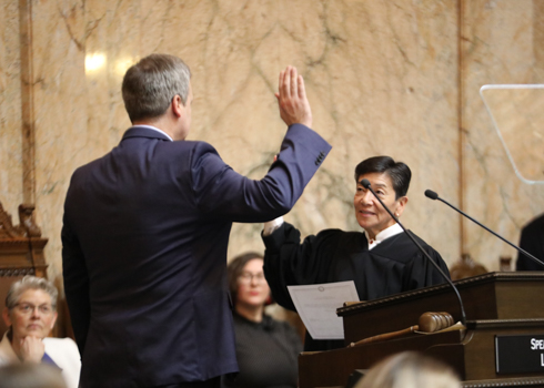
      Washington’s 15th Lands Commissioner Makes History as State’s First Openly LGBTQ+ Executive   Dave Upthegrove was sworn in today...
    • Washington 100 highlights 100 of the state's most distinct geologic formations
      Washington 100: Geotourism Website
      Washington Rocks: New DNR Geotourism Website Helps People Explore State’s Geology    From its craggy coastlines to its icy v...
    • Recreation By Region
      Recreation By Region
      Recreation Resources Maps: State Trust Lands map | Recreation Guide | DNR's GO! Map ...
    1
    2
    3
  • Wildfire Information
    • Information on Wildfires
    • Seasonal Firefighting Team
    • Prepare for Wildfires
  • Commissioner Upthegrove Headshot
    • About Commissioner Upthegrove
    • Bluesky
    • Facebook
    • Instagram
    • E-newsletter
  • Puget Sound, Lakes and Rivers
    • Aquatic Reserves
    • Derelict Vessels
    • Aquatic Leases
  • Recreation - hikers
    • Recreation Openings
    • Where to Go, What to Do
    • Volunteer
    • Trail Maps: Paper and Mobile
    • Campsites
    • More...
  • Maps
    • Trail Maps
    • Find GIS Data
    • More Map Resources
  • Agriculture
    • Lease Land
    • Lease or License an Aquatic Area
    • Do Business and Get Permits
  • Forestry - Photo of a young forest
    • Forest Regulation
    • Forest Practices Application
    • Growing Healthy Forests
    • Landowner Assistance Portal
    • DNR and Washington Forestry
  • Washington Geology - Photo of Mount Ranier
    • Explore Popular Geology
    • Geologic Hazards
    • Publications and Data
    • Washington 100
  • Spotted Owl
    • Natural Areas
    • Habitat Conservation Plans
    • Natural Heritage Program
  • Protecting your state lands
    • Natural Resources Police
    • State Environmental Policy Act (SEPA)
    • Preserving Cultural Resources
  • More...
    Headlines
    DNR, Forest Service Continue Forest Restoration Partnership near...
    State and federal collaboration under the Good Neighbor Authority to restore 150 forest acres and improve 5 miles of forest roads near...
    April 29, 2025
    DNR Will Deliver 15 Surplus Wildfire Engines To Fire Districts...
    The effort is part of the agency’s annual commitment to provide fire service personnel in at-risk areas with critical wildfire...
    April 9, 2025
    Commissioner Upthegrove Statement on Thorpe Land Exchange
    The Exchange of Thorpe Property in Spokane's Latah Valley Will Go Forward as Planned    Commissioner Dave Upthegrove...
    April 1, 2025
  • DNR Logo
    • Boards and Commissions
    • Calendar
    • Funding Schools and Services
  • Tweets by waDNR

FORESTRY

  • Landowner Assistance Portal - NEW
  • Forest Practices Application (FPARS)
  • Family/Small Forest Owner Resources
  • Cultural Resources
  • Forest Health Assistance
  • Forest Legacy Program
  • Silviculture
  • Urban Forestry
  • Other Forest Regulation Resources
  • Other State Forest Resources

Land Leases

  • Agriculture and Grazing
  • Commercial Real Estate
  • Communications Towers
  • Energy
  • Geoducks
  • Land Appraisal Unit
  • Shellfish
  • More Land Lease Resources
  • More Aquatic Lease Resources

Products

  • Timber
  • Biomass
  • Firewood
  • Mining and Minerals
  • Maps and Survey Data
  • Map Resources
  • Trail Maps
  • Seedlings
  • Discover Pass
  • Recreation
  • Product Sales

Aquatic RESOURCES

  • Reserves
  • Creosote Removal
  • Mooring Buoys
  • Razor Clams
  • Aquatic Leasing
  • Other Aquatic Resources

WILDFIRE RESOURCES

  • Fighting Fire
  • Defending Your Home
  • Prevention
  • Burn Permits
  • Industrial Fire Precaution Levels (IFPL)
  • Burn Bans
  • Fire Business Documents
  • Wildfire Ready Neighbors
  • Wildfire Media Contact

EARTH RESOURCES

  • Geologic Information Portal
  • Energy, Mining, and Minerals
  • Earthquakes
  • Landslides
  • Volcanoes
  • Tsunamis
  • Other Geology Resources

More Resources

  • Media Contacts
  • Boards and Commissions
  • Public Disclosure
  • Rule Making
  • SEPA
  • Tribal Relations
  • Youth Education
  • Spanish Resources
  • E-newsletter
  • Accessibility/Civil Rights
  • Open Data
  • Reports
  • Contracting
Back to top
Not a supported browser
  • CONTACT
  • WEBMASTER
  • PRIVACY POLICY
  • LEARNING CENTER
  • OUTLOOK
  • CITRIX
  • VPN
  • ZENDESK
  • EAP
  • DNR EMPLOYEES
© 2025 Department of Natural Resources
SUBSCRIBE TO NEWSLETTERS
Close